

Guidelines : FY2027 ArcticShark Uncrewed Aerial System Missions
Overview
Editor’s note: The calls below have officially closed.
The Atmospheric Radiation Measurement (ARM) User Facility is planning for deployments of its ArcticShark uncrewed aerial system (UAS) in fiscal year 2027 (FY2027) for user-proposed flight missions lasting up to three weeks.
The ArcticShark is a midsized UAS with a 22-foot wingspan and a payload capacity of 100 pounds. It provides a baseline set of instruments, including aircraft state, meteorological state, and land surface properties, along with switchable aerosol payloads.
Two ARM ArcticShark calls are now open for FY2027. ARM is accepting preliminary proposals for ArcticShark missions as part of its annual facility call while also participating in a joint call with the Environmental Molecular Sciences Laboratory (EMSL). Like ARM, EMSL is a U.S. Department of Energy Office of Science user facility.
Awarded projects from the ARM/EMSL and ARM-only calls will begin no earlier than Thursday, October 1, 2026.
Note: ARM’s tethered balloon system (TBS) is also available for the FY2027 calls. Investigators wanting to deploy both the ArcticShark and TBS can indicate their interest in the same letter of intent for the ARM/EMSL call or the same preproposal for the ARM-only call. More information is available through ARM’s Annual Facility Call page.
ARM and ArcticShark Resources
Deployment Information
ARM is planning for potential ArcticShark missions in FY2027 at ARM’s Southern Great Plains (SGP) atmospheric observatory in Oklahoma and the Bankhead National Forest (BNF) observatory in Alabama.
Site Details
ARM/EMSL Call
ARM and EMSL are seeking collaborative research applications through the Facilities Integrating Collaborations for User Science (FICUS) program, which encourages and enables ambitious research projects integrating the expertise and capabilities of multiple user facilities.
Letters of intent will be considered that make use of ArcticShark flights at the BNF or SGP.
The ArcticShark carries a version of EMSL’s STAC aerosol sampler for offline analysis of aerosol particles. The ArcticShark version provides eight filters. The sampler can be programmed for sampling duration or even operated remotely during the flight. For more information about the STAC, read the ARM/EMSL FICUS FY2027 solicitation.
Proposed research should investigate terrestrial-atmosphere processes, atmospheric boundary-layer processes, and microphysical processes of cloud and precipitation formation through aerosol-cloud interactions toward improved mechanistic representations of these processes in a variety of models. Proposed research should address how these processes affect the water cycle; water availability for energy infrastructure, security, and reliability; and earth system processes, especially following a disturbance.
Proposals requesting the STAC and EMSL sample analysis must be submitted to the ARM/EMSL FICUS FY2027 solicitation.
FICUS submissions will require a letter of intent to facilitate the planning of the peer-review process, ensure alignment of proposals to ARM and EMSL missions and capabilities, and assist users in building strong proposals. Letter of intent guidance is available on EMSL’s website.
Letters of intent are due Wednesday, February 4, 2026. FICUS decisions and invitations for full proposals will be sent by Wednesday, March 4, 2026.
EMSL and FICUS Resources
ARM-Only Call
The ARM-only call is for projects that do not require the STAC and EMSL sample analysis. Applicants may propose FY2027 ArcticShark missions for the SGP or BNF.
In their preproposals, investigators should provide information on mission expectations as listed in the next section. Preproposals must be submitted through ARM’s Propose a Field Campaign page.
The due date to submit preproposals for FY2027 ARM ArcticShark missions is Wednesday, February 4, 2026. Decisions and invitations for full proposals will be sent by the end of February 2026.
Submit Your ARM Preproposal
Parameters for Proposing New ArcticShark Missions
Proposals for new ArcticShark missions in FY2027 should provide details regarding mission expectations, including:
- aerosol payload 1 or 2 (one switch per campaign is allowed)
- the flight location (SGP or BNF)
- the desired season or seasons
- the desired flight altitudes
- the number and duration of flights.
Operational Parameters for ArcticShark Missions
The ArcticShark’s minimum operating altitude is driven by obstructions of the radio signals that control the UAS. Maximum flight altitudes are 17,500 feet mean sea level (MSL). Actual maximum flight altitude will be governed by the temperature profile encountered (i.e., lower at warmer temperatures).
ArcticShark missions are no longer than three weeks in duration, and contiguous operations cannot exceed six days before a rest day is required.
All flights must maintain legal separation from clouds. Below 10,000 feet MSL, the required separation from clouds is 500 feet below, 1,000 feet above, and 2,000 feet lateral. At or above 10,000 feet MSL, the required separation from clouds is 1,000 feet below, 1,000 feet above, and 1 statute mile lateral.
Flights into clouds or precipitation or between sunset and sunrise are not allowed. Minimum visibility requirement is 5 statute miles.
Maximum flight duration with the current payloads could be as long as six hours, but practically, a maximum flight duration of five hours should be considered (shorter if dictated by weather or airport traffic).
Other operational limitations may have to be imposed, including but not limited to winds.
Overlapping days may be proposed for the ArcticShark and ARM TBS at the BNF or SGP; however, there are limitations on how close to each other the two platforms can operate.
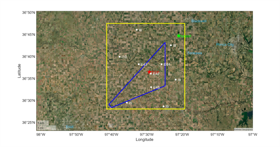
SGP ArcticShark Operations
The ArcticShark will take off and land from Blackwell-Tonkawa Municipal Airport (BKN, 36°44’41″N 97°20’57″W). Flights will be limited to a rectangular operating area bounded by the following four corners:
- 36°47’30″N 97°19’15″W
- 36°28’00″N 97°19’15″W
- 36°28’00″N 97°41’21″W
- 36°47’30″N 97°41’21″W.
Minimum flight altitudes above ground will be 600 feet AGL but along a reasonable number of pre-selected and pre-surveyed routes (1,000 feet otherwise). Maximum flight altitudes are 6,500 feet above MSL when outside the blue triangle shown below and 17,500 feet MSL inside the triangle.
During periods when the TBS is operated, there will be a minimum separation between the TBS and the ArcticShark. That separation has not yet been defined but is expected to be similar to the minimum separation that has been set for the BNF, which is 2 nautical miles.
BNF ArcticShark Operations
The ArcticShark will take off and land from either Cullman Regional Airport (CMD, 34°16’00″N 86°51’30″W) or Posey Field Airport (1M4, 34°16’49″N 87°36’02″W) (see green stars on the map below).
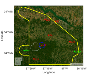
Research flights will be limited to the operating area inside a polygon (solid yellow line on the map) and only east of 87°31’33″W (dashed yellow line).
Typical minimum flight altitudes are 1,500 feet AGL in the operations area. Lower minimum flight altitudes (but not lower than 600 feet AGL) might be possible along a reasonable number of pre-selected and pre-surveyed routes within ~10 nautical miles of the BNF main site (M1 on the map).
During periods when the TBS is operated, ArcticShark flights will be conducted no closer than 2 nautical miles from the BNF M1 site (blue circle on the map).
No sustained operations will be conducted over the Sipsey Wilderness (white line on the map).
Research Funding
Please note that for successful proposals, ARM provides the operational and logistical resources to conduct the proposed mission; however, ARM does not provide research funding associated with the mission.
Get More Information: ARM Field Campaign Processes Webinar
For people interested in the ARM-only or ARM/EMSL FICUS calls, ARM hosted a field campaign processes webinar in January 2026. During this webinar, ARM staff gave an overview of the ArcticShark and TBS capabilities, the proposal process, and responsibilities associated with ARM deployments.
In Case You Missed It
Follow Us:


Keep up with the Atmospheric Observer
Updates on ARM news, events, and opportunities delivered to your inbox
ARM User Profile
ARM welcomes users from all institutions and nations. A free ARM user account is needed to access ARM data.


