

Synoptic Weather Regime Classification Product Released for BNF Observatory
Published: 20 November 2025
The Atmospheric Radiation Measurement (ARM) User Facility has released the Synoptic Weather Regime Classification (SynopWeaReg) machine learning value-added product (VAP) for the Bankhead National Forest (BNF) atmospheric observatory in Alabama.
Currently available in evaluation mode, this VAP provides key insights into the variability of large-scale circulations in the BNF region. It helps reveal how these weather patterns influence cloud formation, aerosol transport, and other atmospheric features over the area and provides broader context for the ARM site observations. The product also assists researchers in identifying specific weather regimes for their studies, such as selecting cases of interest and examining multiple cases under similar large-scale conditions, which can be useful for model evaluation and parameterization development.
This approach provides an avenue to isolate the effects of large-scale weather conditions on atmospheric processes of interest, including their impacts on aerosol-cloud-precipitation relationships.
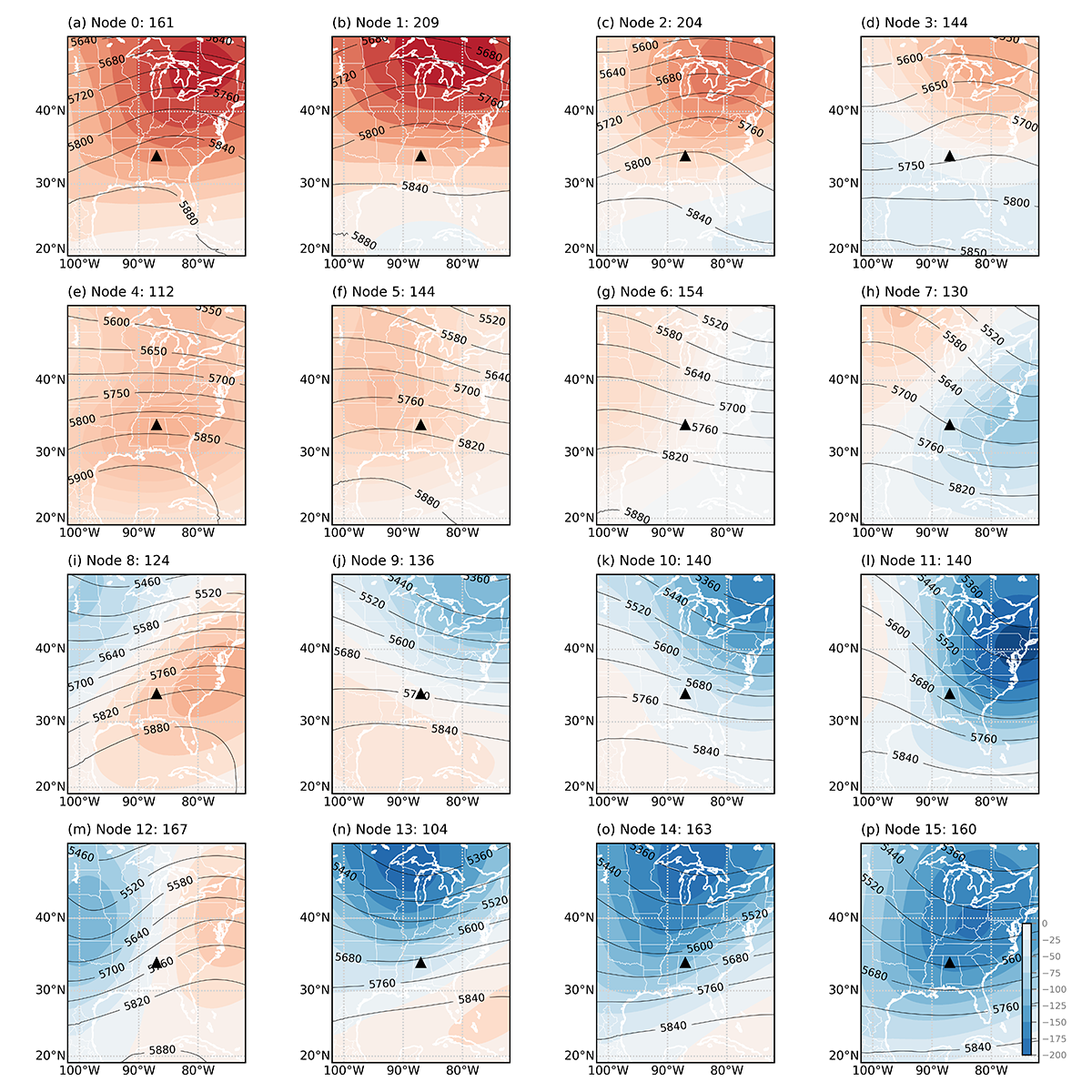
To classify the dominant synoptic weather regimes in the BNF region, the ARM translator team at Brookhaven National Laboratory in New York applied a self-organizing map (SOM), an unsupervised machine learning approach, to 26 years of European Centre for Medium-Range Weather Forecasts Reanalysis version 5 (ERA5) data. These training data included daily 500 hPa geopotential height anomalies—geopotential heights minus the mean state values during the training data period—at 05:00 Coordinated Universal Time (UTC) over the BNF region (19.0°N, 49.0°N, 102.0°W, 72.0°W).
The data analysis distinguished three synoptic regimes: pre-trough regime, post-trough regime, and ridge regime.
For the BNF, the SynopWeaReg VAP provides a single file that identifies the dominant weather regime and SOM node for each day during the spring 2025 season (March 1 through May 31). The SOM nodes are categories produced by the SOM method.
This VAP is planned to cover all ARM sites in the future, with the next data release slated for the North Slope of Alaska observatory.
More information about the VAP can be found on the SynopWeaReg web page.
To ask questions, provide feedback, or report data issues before this evaluation VAP moves to production, please contact SynopWeaReg’s interim translator, Scott Giangrande, or VAP developer Aifang Zhou.
Access the SynopWeaReg data in the ARM Data Center. (To download the data, first create an ARM account.) The data product for the BNF region is listed as synopwearegmam2025ml.
The BNF data can be referenced as doi:10.5439/2572131.
Follow Us:


Keep up with the Atmospheric Observer
Updates on ARM news, events, and opportunities delivered to your inbox
ARM User Profile
ARM welcomes users from all institutions and nations. A free ARM user account is needed to access ARM data.


