An official website of the United States government





High-Resolution ARM Best Estimate Data Sets Now Available
Published: 30 June 2026
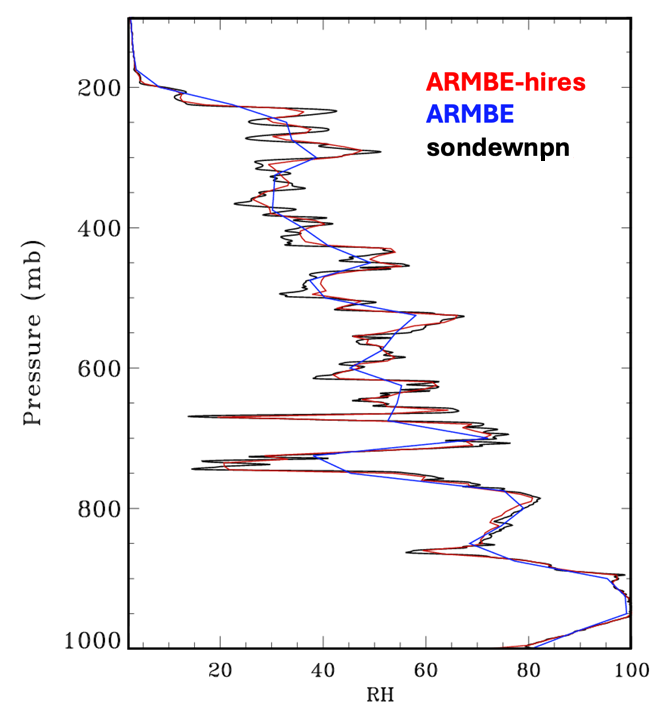
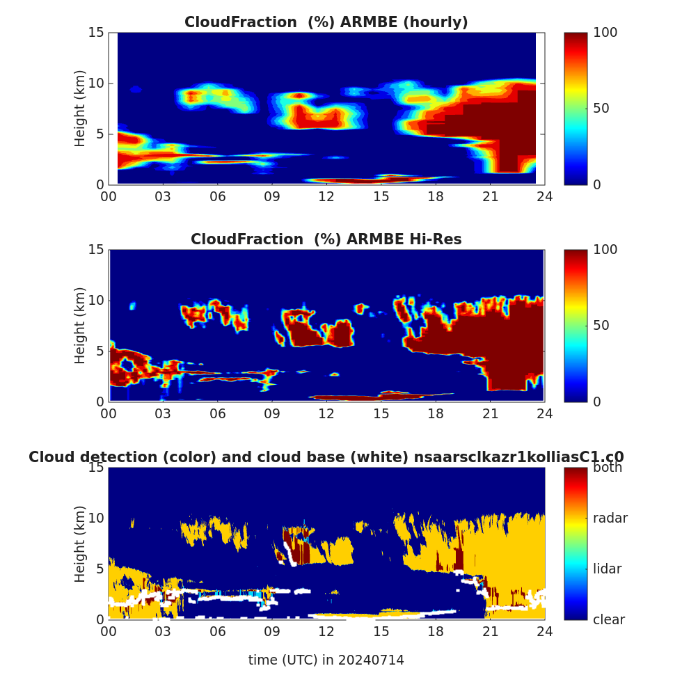
The Atmospheric Radiation Measurement (ARM) User Facility provides tailored datastreams known as ARM Best Estimate (ARMBE) data products for use in the evaluation of global earth system models (ESMs). ARMBE products assemble quantities that are both well observed by ARM over many years and often used in model evaluation into single data sets. Historically, these products have consisted of hourly averages and thus had temporal resolution comparable to a typical resolution used in ESM output.
For users looking to evaluate kilometer-scale ESMs, ARM now provides high-resolution versions of two ARMBE products, ARM Best Estimate Atmospheric Measurements (ARMBEATM) and ARM Best Estimate Cloud Radiation (ARMBECLDRAD). The new high-resolution products are labeled as ARMBEATMHIRES and ARMBECLDRADHIRES in the ARM Data Center.
ARMBEATMHIRES contains basic atmospheric quantities, and ARMBECLDRADHIRES provides cloud and radiation quantities. These quantities are similar to the ones in the standard ARMBEATM and ARMBECLDRAD products, but the high-resolution products capture more spatial variability in cloud and environmental structures.
In ARMBEATMHIRES, the temporal resolution has been increased from one hour to 10 minutes, and the vertical resolution for sounding variables has been increased from 25 millibars to 5 millibars. Also, two new variables, height-on-pressure coordinate and pressure-on-height coordinate, have been added to support model re-gridding.
In ARMBECLDRADHIRES, the temporal resolution has been increased from one hour to 10 minutes, enabling improved characterization of subhourly cloud and radiation variability. The vertical resolution for clouds remains the same as in the standard ARMBECLDRAD product (45 meters).
Find more information about ARMBE data products on the ARMBE web page and Xie et al. (2010).
ARMBEATMHIRES and ARMBECLDRADHIRES are both available as evaluation products for ARM’s Southern Great Plains, North Slope of Alaska, and Eastern North Atlantic atmospheric observatories for the years 2023 and 2024. The files are in netCDF format.
Access the data in the ARM Data Center. (To download the data, first create an ARM account.)
To ask questions about these evaluation data or provide feedback before they move to production, please contact product developer Yuying Zhang or ARM translator Shaocheng Xie.
Please reference the ARMBEATMHIRES data as doi:10.5439/3019691 and the ARMBECLDRADHIRES data as doi:10.5439/3015534.
Reference: Xie S, RB McCoy, SA Klein, RT Cederwall, WJ Wiscombe, EE Clothiaux, KL Gaustad, J Golaz, S Hall, MP Jensen, KL Johnson, Y Lin, CN Long, JH Mather, RA McCord, SA McFarlane, G Palanisamy, Y Shi, and DD Turner. 2010. “ARM Climate Modeling Best Estimate Data – A new data product for climate studies.” Bulletin of the American Meteorological Society, 91(1):13-20, https://doi.org/10.1175/2009bams2891.1

Follow Us:






Keep up with the Atmospheric Observer
Updates on ARM news, events, and opportunities delivered to your inbox
ARM User Profile
ARM welcomes users from all institutions and nations. A free ARM user account is needed to access ARM data.