An official website of the United States government





ARM Releases New Cloud Optical Depth Product
Published: 8 July 2026
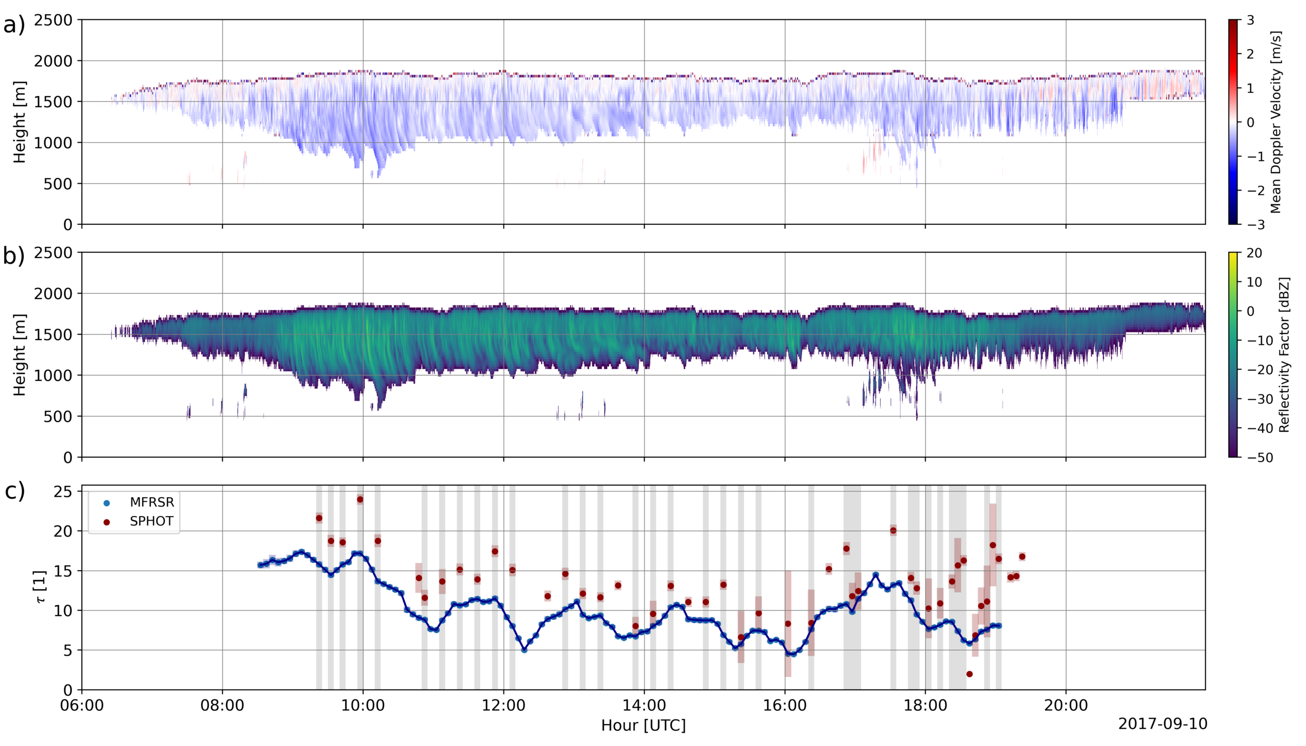
At its fixed-location atmospheric observatories and mobile sites, the Atmospheric Radiation Measurement (ARM) User Facility operates Cimel sunphotometers, multi-channel scanning photometers for passive remote sensing of the atmosphere. The sunphotometers are calibrated and maintained by the AErosol RObotic NETwork (AERONET), which also processes certain data as part of its global archive.
ARM has developed the Three-Channel Sunphotometer Cloud Mode value-added product (SPHOTCOD VAP) to provide information on cloud properties for process studies, including insights on the cloud droplet effective radius, cloud optical depth, and/or liquid water path.
SPHOTCOD retrieves cloud properties from sunphotometer data at three channels (wavelengths of 440, 870, and 1640 nanometers) following published methods of Chiu et al. (2012) and Sookdar et al. (2025). For its inputs, the VAP uses zenith radiance measurements at the three wavelengths from AERONET, solar constant values, and surface albedo data from the satellite-based Moderate Resolution Imaging Spectroradiometer (MODIS).
The VAP retrieves two cloud quantities, the cloud optical depth and cloud droplet effective radius, and estimates liquid water path based on these quantities. Scientists can use the data for studies of cloud processes, cloud-aerosol interactions, and cloud radiative impacts.
More information about the VAP, including the technical report, can be found on the SPHOTCOD web page.
SPHOTCOD is available in daily netCDF files for the following ARM sites and date ranges:
- the Southern Great Plains (SGP) Central Facility near Lamont, Oklahoma, from January 1, 2014, through December 29, 2019
- the Eastern North Atlantic (ENA) observatory from January 2, 2014, through December 31, 2019
- the ARM Mobile Facility site in Gothic, Colorado, during the Surface Atmosphere Integrated Field Laboratory (SAIL) campaign from September 2, 2021, through June 15, 2023
- the ARM Mobile Facility site in La Jolla, California, during the Eastern Pacific Cloud Aerosol Precipitation Experiment (EPCAPE) from February 15, 2023, through February 13, 2024.
Additional VAP data will be processed from the SGP and ENA along with data from the Bankhead National Forest observatory in Alabama and the 2018–2019 Cloud, Aerosol, and Complex Terrain Interactions (CACTI) campaign in Argentina.
Access the SPHOTCOD data in the ARM Data Center. (To download the data, first create an ARM account.)
For questions or to report data issues, please contact ARM translator Min Deng, science sponsors Christine Chiu and Scott Giangrande, and/or VAP developer Lynn Ma.
Data can be referenced as doi:10.5439/1668057.
References:
Chiu JC, A Marshak, CH Huang, T Varnai, RJ Hogan, DM Giles, BN Holben, EJ O’Connor, Y Knyazikhin, and WJ Wiscombe. 2012. “Cloud droplet size and liquid water path retrievals from zenith radiance measurements: examples from the Atmospheric Radiation Measurement Program and the Aerosol Robotic Network.” Atmospheric Chemistry and Physics, 12(21):10313-10329, https://doi.org/10.5194/acp-12-10313-2012
Sookdar K, S Giangrande, J Rausch, L Ma, M Wang, D Wang, M Jensen, C Hung, and J Chiu. 2025. “Marine and continental stratocumulus cloud microphysical properties obtained from routine ARM Cimel sunphotometer observations.” Atmospheric Measurement Techniques, 18(21):6271-6289, https://doi.org/10.5194/amt-18-6271-2025

Follow Us:






Keep up with the Atmospheric Observer
Updates on ARM news, events, and opportunities delivered to your inbox
ARM User Profile
ARM welcomes users from all institutions and nations. A free ARM user account is needed to access ARM data.