An official website of the United States government





First Characterized and Corrected BNF Radar Data Now Available
Published: 6 July 2026
The Atmospheric Radiation Measurement (ARM) User Facility has released its first set of characterized and corrected radar data from the Bankhead National Forest (BNF) atmospheric observatory in northern Alabama. These data are b1-level, meaning they underwent correction and quality control processes beyond ARM’s standard quality checks and corrections.
ARM has produced b1-level data for the following BNF radars:
- the second-generation C-Band Scanning ARM Precipitation Radar (CSAPR2)
- the Ka-Band Scanning ARM Cloud Radar (KASACR)
- the second-generation Ka-Band ARM Zenith Radar (KAZR2)
- the X-Band Scanning ARM Cloud Radar (XSACR).
These radars are located at three sites in and around the forest, collecting data to help researchers understand how the forest canopy structure, surface fluxes, and regional meteorology influence the formation and evolution of boundary-layer clouds and precipitation systems. The KAZR2 operates within the forest at the BNF main site, the KASACR and XSACR are located about 16.5 kilometers northeast of the KAZR2, and the CSAPR2 is another 21 kilometers northeast of the KASACR and XSACR.
The KAZR2 operates with three modes—general sensitivity (GE), moderate sensitivity (MD), and precipitation sensitivity (PR)—to collect data on cloud dynamics and properties. CSAPR2 observations provide details on the microphysical properties and life cycle of convective clouds, while data from the KASACR and XSACR are useful for information on cloud microstructures.
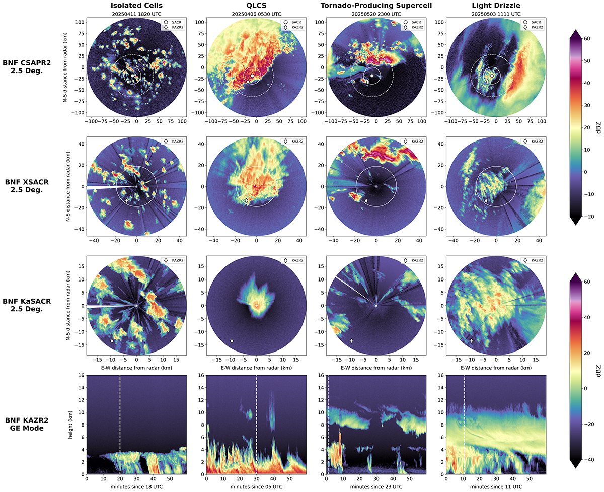
To produce the quality-controlled b1-level data, ARM staff applied reflectivity offsets and meteorological echo masks to each of the radar data sets.
Staff estimated the reflectivity offsets by cross-comparing ARM radar data with values from the Huntsville National Weather Service WSR-88D (Weather Surveillance Radar) and disdrometer measurements from the BNF main site.
The meteorological echo masks allow scientists to quickly remove background noise and clutter.
Given the dual-polarization nature of the CSAPR2 and XSACR, these radar data sets also include differential reflectivity corrections, specific differential phase calculations, and attenuation estimates.
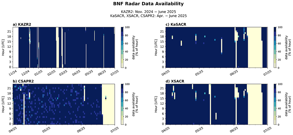
The KAZR2 b1-level data cover the beginning of operations in mid-November 2024 through June 2025. The CSAPR2, KASACR, and XSACR data cover an intensive operational period during the April–June 2025 convective season, when the scanning radars consistently performed the same scans.
The corrected and characterized BNF radar data sets are available now in CfRadial format.
More information about the data, including the radar analysis, related corrections, and other known data quality issues (e.g., CSAPR2 beam blockage and azimuth flips), can be found in the BNF b1-level radar data processing report for spring 2025.
Subsequent releases of more recent b1-level data are scheduled toward the end of fiscal year 2026.
Access the BNF b1-level radar data in the ARM Data Center. (To download the data, first create an ARM account.)
For questions or to report data issues, please contact the ARM radar team.
To cite the data, please use the following DOIs:
- CSAPR2: doi:10.5439/2001313
- KASACR: doi:10.5439/1877338
- KAZR2: doi:10.5439/2589318 (GE mode), doi:10.5439/2589319 (MD mode), and doi:10.5439/2589320 (PR mode)
- XSACR: doi:10.5439/2001296.

Follow Us:






Keep up with the Atmospheric Observer
Updates on ARM news, events, and opportunities delivered to your inbox
ARM User Profile
ARM welcomes users from all institutions and nations. A free ARM user account is needed to access ARM data.