

2026 AMS Presentations Featuring ARM Data
Published: 21 January 2026
 The 2026 American Meteorological Society (AMS) Annual Meeting will be held from January 25 to 29 at the George R. Brown Convention Center in Houston, Texas, and online. With more than 7,000 attendees expected, the meeting might feel overwhelming. We make it easy for you to find Atmospheric Radiation Measurement (ARM) User Facility-relevant science, meet up with colleagues, and discover new connections during the event.
Below is a list of ARM-related AMS meeting highlights (all times Central). Information is subject to change; please check the AMS Annual Meeting website for the most up-to-date information.
Discover more ARM-related presentations and posters, and add your presentation to be featured on the ARM website.
Check out ARM-Related Presentations:
- Atmospheric Observatory Presentations
- Featured Field Campaign Presentations
- Full List of ARM-Related Presentations
Atmospheric Observatory Presentations
Bankhead National Forest (BNF)
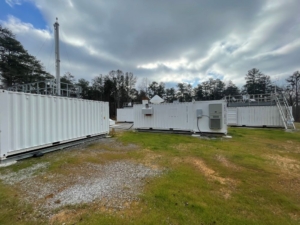
ARM’s Bankhead National Forest (BNF) atmospheric observatory began operating in October 2024 in northwestern Alabama. Researchers are using BNF data to learn about clouds, aerosols, and land-atmosphere interactions, which in turn will lead to improvements in earth system models.
- POSTER SESSION—Mesoscale Processes
Sunday, January 25, 7–9 p.m., Hall B3 (Convention Center)
Reported BNF presentation:- S218: Investigating Continental Mid-Latitude Cold Pools in Bankhead National Forest. Angel Bright Chui, University of Washington.
- ORAL SESSION—1: The NASA INCUS Mission: Observing Convective Updraft Dynamics and Anvil Properties and Extent I
Monday, January 26, 8:30–10 a.m., Room 370D (Convention Center)
Reported BNF presentation:- 1.6: TIME-SLICE: Adaptive Sampling to quantify Convective Mass Flux for INCUS Calibration/Validation. Sean William Freeman, University of Alabama in Huntsville.
- ORAL SESSION—2: Phased Array Weather Radar II
Monday, January 26, 10:45 a.m.–noon, Room 370A (Convention Center)
Reported BNF presentation:
- POSTER SESSION—Aerosols, Ice Particles, & Clouds
Monday, January 26, 3–4:30 p.m., Hall B3 (Convention Center)
Reported BNF presentation:- 198: Characterizing the Ice Nucleation Potential of Particles in Bankhead National Forest: Investigating the Impacts of Bioaerosols. Katie Samantha Chan, University of California, Los Angeles.
- ORAL SESSION—4: Multi-instrument Observations of the Planetary Boundary Layer II
Monday, January 26, 4:30–6 p.m., Room 351E (Convention Center)
Reported BNF presentation:- 4.5: The One-Stop Shop for Planetary Boundary Layer Analysis: The Atmospheric data Community Toolkit (ACT). Joseph Robert O’Brien, Argonne National Laboratory.
- ORAL SESSION—4A: Observing and Modeling Human and Natural Impacts on Carbon Reservoirs II
Monday, January 26, 4:30–6 p.m., Room 342E (Convention Center)
Reported BNF presentation:- 4A.1: Synoptic Scale Variability of Surface Layer CO₂ Exchange over the Southeast US. Nanditha Subhash, Texas Tech University.
- POSTER SESSION—2: Cloud Physics Posters II
Tuesday, January 27, 3–4:30 p.m., Hall B3 (Convention Center)
Reported BNF presentation:- 507: Intercomparison of Surface Drop Size Distributions and Polarimetric Radar Profiles at the ARM AMF3 Bankhead National Forest Site. Bhupendra Raut, Argonne National Laboratory.
- ORAL SESSION—10: Fundamental Research and Applications of Weather Radar IV
Wednesday, January 28, 10:45 a.m.–noon, Room 370A (Convention Center)
Reported BNF presentation:- 10.1: Observed Characteristics of Physical Processes Associated with the Propagation and Evolution of Severe, Cool-Season QLCSs as Determined from Multiple Ground-Based Remote Sensing Instruments. Kevin Knupp, University of Alabama in Huntsville.
- POSTER SESSION—Aerosol-Cloud Interactions in Warm Clouds
Wednesday, January 28, 3–4:30 p.m., Hall B3 (Convention Center)
Reported BNF presentation:- 728: Impacts of Pollen on Aerosol Number Budget and Cloud Formation Processes. Tamanna Subba, Brookhaven National Laboratory.
- POSTER SESSION—26th Symposium on Meteorological Observation and Instrumentation
Thursday, January 29, 3–4:30 p.m., Hall B3 (Convention Center)
Reported BNF presentation:- 884: Enhancing Aerosol Remote Sensing with Real-Time Extinction Profile Estimates from Micropulse Lidars. Paytsar Muradyan, Argonne National Laboratory.
- POSTER SESSION—Aerosol-Cloud Interactions in Deep Convective Clouds
Thursday, January 29, 3–4:30 p.m., Hall B3 (Convention Center)
Reported BNF presentation:- 953: Examining Aerosol Impacts on Southeastern Convective Clouds Using a Cloud Tracking Framework. Kyra Britton, University of Alabama in Huntsville.
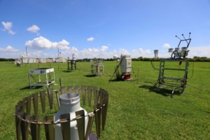
Southern Great Plains (SGP)
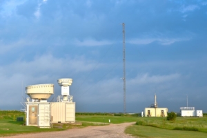
The Southern Great Plains (SGP) atmospheric observatory was the first field measurement site established by ARM. Operational since 1992, the SGP observatory consists of in situ and remote-sensing instrument clusters arrayed across north-central Oklahoma and offers high-quality data and simulations for use by the atmospheric science community.
- ORAL SESSION—3A: Frontiers in Earth System Modeling I
Monday, January 26, 1:45–3 p.m., Grand Ballroom B (Convention Center)
Reported SGP presentation:- 3A.5: Representing the Impact of Land Cover on the Atmosphere in the Community Earth System Model (CESM2) (Invited). Meg Devlan Fowler, National Science Foundation National Center for Atmospheric Research.
- ORAL SESSION—5A: Agriculture-Atmosphere Interactions
Tuesday, January 27, 8:30–10 a.m., Room 342E (Convention Center)
Reported SGP presentation:- 5A.5: Vertical Gradients in New Particle Formation and Growth: Influence of Agricultural Emissions and Implications for Cloud Droplet Number (Invited).
Eleanor Browne, University of Colorado Boulder.
- 5A.5: Vertical Gradients in New Particle Formation and Growth: Influence of Agricultural Emissions and Implications for Cloud Droplet Number (Invited).
- ORAL SESSION—7: Emerging Sensors and Observing Technologies
Tuesday, January 27, 1:45–3 p.m., Room 340B (Convention Center)
Reported SGP presentation:- 7.3: Direct Atmospheric Water Vapor Measurements with Open-path Dual-comb Spectroscopy on an Aircraft. Luke Horstman, Honeywell Aerospace Technologies.
- ORAL SESSION—J10A: Aerosol-Cloud Interactions in Warm Clouds Session I
Wednesday, January 28, 10:45 a.m.–noon, Room 372C (Convention Center)
Reported SGP presentation:- J10A.2: Use of an Explainable Machine Learning Model to Disentangle Aerosol-Cloud Interactions for Warm Clouds at Multiple ARM sites. Shujun Zhou, University of Maryland, College Park.
- ORAL SESSION—9A: Innovations in Meteorological Measurement: Remote Sensing, UAS, and Data Fusion I
Wednesday, January 28, 8:30–10 a.m., Room 351E (Convention Center)
Reported SGP presentation:- 9A.1: WRF Single-Column Sensitivity to PBL Schemes and Moisture During the August 21st, 2017 Total Solar Eclipse. Wesley Taylor, Millersville University.
- POSTER SESSION—26th Symposium on Meteorological Observation and Instrumentation
Wednesday, January 28, 3–4:30 p.m., Hall B3 (Convention Center)
Reported SGP presentation:- 650: Comparing Observed and Modeled Divergence Across Three Southern Great Plains Sites. Danica Marr, Embry-Riddle Aeronautical University.
- ORAL SESSION—12B: Advancing R2O and O2R in Weather Analysis and Forecast Systems: Technologies, Methodologies, and Approaches to Meet Evolving Forecasting Needs: Part IV of IV: Modeling and Data Assimilation
Wednesday, January 28, 4:30–6 p.m., Room 371A (Convention Center)
Reported SGP presentation:- 12B.3: Evaluating the Kain-Fritsch Convective Parameterization Scheme Across Multiple Spatial Scales Using Observationally-Derived Trigger Function Variables. David T. Haliczer, University of Alabama in Huntsville.
- ORAL SESSION—12B: Aerosol-Cloud Interactions in Deep Convective Clouds Session I
Wednesday, January 28, 4:30–6 p.m., Room 372C (Convention Center)
Reported SGP presentation:- 12B.3: Causes and Implications of Significant Correlations Between Continental Aerosols and Meteorology Affecting Convective Clouds. Adam Varble, Pacific Northwest National Laboratory.
- ORAL SESSION—13B: Weather Regimes: Predictability, Prediction, and Applications I
Thursday, January 29, 8:30–10 a.m., Grand Ballroom B (Convention Center)
Reported SGP presentation:- 13B.5: Investigating Long-Range Smoke Transport to the Southern Great Plains, USA via Weather Regimes. Kyle David Eskew, University of Oklahoma.
- POSTER SESSION—Aerosol-Radiation Interactions
Thursday, January 29, 3–4:30 p.m., Hall B3 (Convention Center)
Reported SGP presentation:- 960: Characterization of Dust Vertical Distribution and Relationship to Cloud Variability Using ARM Observations. Guoqing Gong, University of California, Merced.
- POSTER SESSION—26th Symposium on Meteorological Observation and Instrumentation
Thursday, January 29, 3–4:30 p.m., Hall B3 (Convention Center)
Reported SGP presentation:- 869: Interactions Between Low-Level Jets and Nocturnal Boundary Layer Processes over the Southern Great Plains: Insights from PECAN Observations and WRF Simulations. Sharad Pandey, University of Maryland, Baltimore County.
North Slope of Alaska (NSA)
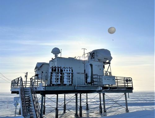
ARM’s North Slope of Alaska (NSA) atmospheric observatory provides comprehensive data about cloud and radiative processes at high latitudes. The NSA central facility at Utqiaġvik (formerly Barrow) has hosted research near the coast of the Arctic Ocean since 1997.
The NSA is a focal point for atmospheric and ecological research activity in the Arctic. Scientists use data from the NSA to improve the representation of high-latitude cloud and radiation processes in earth system models.
- ORAL SESSION—3: Mixed-Phase and Ice Clouds: Lab Studies, Field Studies and Parameterization
Monday, January 26, 1:45–3 p.m., Room 371E (Convention Center)
Reported NSA presentation:- 3.4: Meteorological Controls on Arctic Mixed-Phase Cloud Properties: Evaluation of Climatological Data and MOSAiC Case Studies. Andrew Michael Dzambo, Cooperative Institute for Severe and High-Impact Weather and Research Operations.
- POSTER SESSION—1: Cloud Physics Posters I
Monday, January 26, 3–4:30 p.m., Hall B3 (Convention Center)
Reported NSA presentation:- 227: Turbulence and Its Role in Ice Microphysics from Millimeter-Wavelength Radar Observations. Jialin Yan, Stony Brook University.
- POSTER SESSION—2: Cloud Physics Posters II
Tuesday, January 27, 3–4:30 p.m., Hall B3 (Convention Center)
Reported NSA presentation:- 505: Classifying Thermodynamic Cloud Phase Using Machine Learning Models. Damao Zhang, Pacific Northwest National Laboratory.
- ORAL SESSION—12: High-Latitude Mixed-Phase Cloud Processes
Wednesday, January 28, 4:30–6 p.m., Room 371E (Convention Center)
Reported NSA presentation:- 12.4: A Radar View of Ice Microphysics and Turbulence in Arctic Mixed-phase Cloud System. Jialin Yan, Stony Brook University
Featured Field Campaign Presentations
TRacking Aerosol Convection interactions ExpeRiment (TRACER)
The TRacking Aerosol Convection interactions ExpeRiment (TRACER), which ran from October 2021 through September 2022, provided convective cloud observations with high space and time resolution over a broad range of environmental and aerosol conditions around the Houston, region.
As part of TRACER, ARM deployed a mobile observatory southeast of downtown Houston, a scanning precipitation radar south of downtown, and an ancillary site southwest of the city, where tethered balloon systems were launched. Together, these ARM measurements are helping researchers better understand the variability of aerosols and meteorology between the urban Houston area and surrounding rural environments.
TRACER’s lead scientist, Michael Jensen, is chairing the following TRACER-related AMS sessions:
- ORAL SESSION—J5A: Aerosol, Convection and Air Quality in the Coastal Urban Environment of Southeast Texas I
Tuesday, January 27, 8:30–10 a.m., Room 372C (Convention Center)
Reported TRACER presentations:- J5A.1: Insights from a Multi-Platform Tracking Dataset for Isolated Deep Convection over Houston, Texas. Siddhant Gupta, Argonne National Laboratory.
- J5A.2: Exploring Attributes of Nascent Convective Clouds, Their Initiation Mechanisms, and Environments during TRACER. Christopher J. Nowotarski,
Texas A&M University. - J5A.3: Relating the Presence and Frequency of Lightning in the TRACER Field Campaign to Aerosol and Meteorological Environments.
Samuel Thomas Gardner, Texas Tech University. - J5A.4: Aerosol Impacts on Convective Cell Lifecycle in Model-Simulated and Radar-Observed TRACER Events. Stephen M. Saleeby, Colorado State University.
- J5A.5: Meteorological and Aerosol Controls on Deep Convective Cell Properties over Houston during TRACER. Yongjie Huang, Center for Analysis and Prediction of Storms, University of Oklahoma.
- J5A.6: Aerosol-Cloud Interaction within Coastal Cumulus Congestus Clouds Observed during ESCAPE and TRACER. Azusa Takeishi, National Science Foundation National Center for Atmospheric Research.
- POSTER SESSION—Aerosol, Convection and Air Quality in the Coastal Urban Environment of Southeast Texas
Tuesday, January 27, 3–4:30 p.m., Hall B3 (Convention Center)
Reported TRACER presentations:- 423: Examining Errors in UAS Observations from Field Projects Using Comparisons with Traditional Observations and Models. Nathaniel Breaux, Texas A&M University.
- 424: Influence of Moisture Source on Aerosol and Isotope Characteristics in Houston Rainfall. Lindsay White, Rice University.
- 425: Simulating the Impact of Biomass Burning Aerosols on a Sea-Breeze Storm Event during TRACER. Lijun Zhao, Texas A&M University.
- 426: A Climatology of Inland-Propagating Convection over the Texas Gulf Coast. Malinda Sukithabhaya Bandara Millangoda, University of Houston.
- 427: A Comparison of Model Analysis Gridpoint Soundings to Radiosonde Observations from the TRACER Field Campaign. Camrynne Rose Ellis, Texas A&M University.
- 428: Sources and Ozone Forming Potential of VOCs at Industrial, Urban, and Forested Sites in Houston, TX. Prakash Sharma, Baylor University.
- 430: Coastal Urban Thunderstorm Lifecycles from Radar Observations. Jean Carlos Pena, University at Albany.
- 431: Impact of a Local Wildfire and Sea Breeze Front on Urban Aerosol and VOC Composition in Houston. Nushrat Jahan Chowdhury, Baylor University.
- 432: Vertical Mixing of Aerosol Properties during the TRACER field campaign – A Tethered Balloon Study. Jayla Fontenette, Texas Southern University.
- 433: Cloud and Radiation Characteristics Associated with Sea-Breeze Boundaries in the Southeast Texas Region. Michelle Jones, Texas Southern University.
- 434: Direct Radiative Forcing of Aerosols under Mesoscale Meteorological Influences in Southern Texas. Tamanna Subba, Brookhaven National Laboratory.
- 436: Linking Aerosol Morphology and Composition to Cloud-Relevant Properties Using a New Raman Microspectroscopy Method. Taylor A. Pena, Texas A&M University.
- 437: An Observational Exploration of Cold Pool Outflow and the Properties of Secondary Convection. Aryca’Rae Williams, Texas Southern University.
- 439: The TRacking Aerosol Convection Interactions ExpeRiment (TRACER): Motivation, Measurements and Science. Michael P. Jensen, Brookhaven National Laboratory.
- ORAL SESSION—J8A: Aerosol, Convection and Air Quality in the Coastal Urban Environment of Southeast Texas Session II
Tuesday, January 27, 4:30–6 p.m., Room 372C (Convention Center)
Reported TRACER presentations:- J8A.1: Summer Aerosol and Trace Gas Observations in Houston, Texas – Urban, Dust, and Organic Growth Aerosol Regimes and Sources. Allison C. Aiken, Los Alamos National Laboratory.
- J8A.2: Disentangling Local and Regional Aerosol Regimes during the ARM TRACER Campaign Using in-situ Observations and Self-Organizing Maps.
Maria Anna Zawadowicz, Brookhaven National Laboratory. - J8A.3: Ice-Nucleating Particles Around Houston and the Western U.S. Gulf Coast: Interactions of Saharan Dust and Urban Air Pollution. Ryan Patnaude, Colorado State University/National Science Foundation National Center for Atmospheric Research.
- J8A.4: Role of Insoluble Inclusions in Ice Nucleation of Inorganic–Organic Mixed Core–Shell Aerosols in Atmospheric Ice Nucleation. Ziying (Nancy) Lei, University of Tennessee.
- J8A.5: Improved Understanding of Ozone Air Quality in Houston and Surrounding Waters through Integrated Modeling and Analysis of 2021-2023 TRACER-AQ Campaign Observations. Yuxuan Wang, University of Houston.
- J8A.6: Instrument Emulation for Humidified Aerosol Measurement Integration and Mixing State Retrieval. Kyle Gorkowski, Los Alamos National Laboratory.
- ORAL SESSION—J9A: Aerosol, Convection and Air Quality in the Coastal Urban Environment of Southeast Texas Session III
Wednesday, January 28, 8:30–10 a.m., Room 372C (Convention Center)
Reported TRACER presentations:- J9A.1: Pinned Clouds Over Industrial Heat Sources in Houston. Rusen Oktem, University of California, Berkeley/Lawrence Berkeley National Laboratory.
- J9A.3: Modelling Coastal Urban Thermodynamic Modifications of Convective Thunderstorms. Jean Carlos Pena, University at Albany.
- J9A.4: Coastal Air Quality Observations during the TRACER IOP. Paul J. Walter, St. Edward’s University.
- J9A.5: Single-Particle Insights into Bioaerosol Variability from Ground to Aloft During TRACER 2022. Nurun Nahar Lata, Pacific Northwest National Laboratory.
- J9A.6: Using Lagrangian Analyses to Understand the Full Scope of Urban New Particle Formation During the Houston TRACER-MAP Campaign. Hannah Grace Marti, Colorado State University.
Additional TRACER-related presentations:
- POSTER SESSION—Observations and Instrumentation
Sunday, January 25, 7–9 p.m., Hall B3 (Convention Center)
Reported TRACER presentation:- S226: Intercomparison of Radiosonde Measurements During the 2022 TRACER Campaign. Zohaer Al Mahatab, St. Edward’s University.
- POSTER SESSION—Atmospheric Chemistry, Aerosols, and Air Quality
Sunday, January 25, 7–9 p.m., Hall B3 (Convention Center)
Reported TRACER presentation:- S80: Identifying Sea Breeze Impacts on Coastal Air Quality Near Houston During TRACER. Joshua Andrew Yoshioka, St. Edward’s University.
- ORAL SESSION—J1A: Advances in Numerical Modeling of Aerosol-Cloud Interactions: Moment-, Bin- and Particle-Resolved Methods and Beyond
Monday, January 26, 8:30–9:45 a.m., Room 372C (Convention Center)
Reported TRACER presentation:- J1A.2: Modeling Cloud Chamber Experiments and Field Measurements with the Particula Python Package. Kyle Gorkowski, Los Alamos National Laboratory.
- POSTER SESSION—Cloud and Precipitation Responses to Aerosol Pollution, Weather Modification, and Climate Intervention
Tuesday, January 27, 3–4:30 p.m., Hall B3 (Convention Center)
Reported TRACER presentation:- 443: Linking the Lifecycle of Deep Convection with Cold Pool Outflow using SACR Observations During the TRACER Campaign. Min Deng, Brookhaven National Laboratory.
- POSTER SESSION—Fifth Symposium on Community Modeling and Innovation
Tuesday, January 27, 3–4:30 p.m., Hall B3 (Convention Center)
Reported TRACER presentation:- 499: Performance of E3SM’s Global Storm-Resolving Model in Representing Deep Convection Over Houston. Raymond Kwaku Twumasi Oware, University of Houston.
- ORAL SESSION—8: Coastal Meteorological Processes
Tuesday, January 27, 4:30–6 p.m., Room 360D (Convention Center)
Reported TRACER presentation:- 8.4: Sea Breeze Convection over the Texas Gulf Coast in DOE’s Global Storm-Resolving Model. Youtong Zheng, University of Houston.
- POSTER SESSION—Atmospheric Composition Modeling and Analysis Program (ACMAP)
Wednesday, January 28, 3–4:30 p.m., Hall B3 (Convention Center)
Reported TRACER presentation:- 626: Towards a Better Understanding of the Role of Oxidants in Urban Air Quality and Atmospheric Oxidative Capacity in Houston. Akinleye Folorunsho, Baylor University.
- ORAL SESSION—12B: Aerosol-Cloud Interactions in Deep Convective Clouds Session I
Wednesday, January 28, 4:30–6 p.m., Room 372C (Convention Center)
Reported TRACER presentations:- 12B.3: Causes and Implications of Significant Correlations Between Continental Aerosols and Meteorology Affecting Convective Clouds. Adam Varble, Pacific Northwest National Laboratory.
- 12B.4: Investigation of Aerosol-Cloud Interactions in Radar and Satellite Data from Houston, Texas, and Manus, Brazil. Hannah C. Vagasky, Atmospheric and Environmental Research.
- ORAL SESSION—13: Bridging Experiments, Observations, and Models to Develop Process-Level Understanding of Mixed-Phase Clouds
Thursday, January 29, 8:30–10 a.m., Room 371E (Convention Center)
Reported TRACER presentation:- 13.2: Secondary Ice Production in Deep Convective Clouds over Coastal Urban Areas: Insights from TRACER Observations and Large-Eddy Simulations. Yongjie Huang, Center for Analysis and Prediction of Storms, University of Oklahoma.
- ORAL SESSION—J13B: Aerosol-Cloud Interactions in Deep Convective Clouds Session II
Thursday, January 29, 8:30–10 a.m., Room 372C (Convention Center)
Reported TRACER presentations:- J13B.2: Using Statistical Learning Methods and Ensemble Modeling to Determine the Role of Aerosols and Environmental Conditions on Convective Cloud Properties. Zachary J. Lebo, University of Oklahoma.
- J13B.3: Quantifying Meteorological and Aerosol Controls on Isolated Deep Convection Using Idealized Ensembles Informed by TRACER Observations.
Milind Sharma, Texas A&M University.
- POSTER SESSION—Aerosol-Cloud Interactions in Deep Convective Clouds
Thursday, January 29, 3–4:30 p.m., Hall B3 (Convention Center)
Reported TRACER presentation:- 954: Microphysical Processes and Associated Storm Properties from Radar Observations during the TRACER Field Program. Manikandan Rajagopal, University of Oklahoma.
- POSTER SESSION—Wildfire Influence on Aerosol, Cloud, and Climate
Thursday, January 29, 3–4:30 p.m., Hall B3 (Convention Center)
Reported TRACER presentation:- 968: Smoke-Enhanced Sea Breeze Convection during TRACER. Timothy Logan, Texas A&M University.
Coast-Urban-Rural Atmospheric Gradient Experiment (CoURAGE)
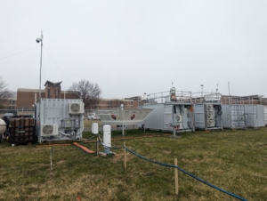
The Coast-Urban-Rural Atmospheric Gradient Experiment (CoURAGE) operated from December 2024 through November 2025 in and around Baltimore, Maryland. As part of the campaign, ARM deployed one of its three mobile observatories at Morgan State University’s Clifton Park site in Baltimore. Ancillary ARM sites operated in rural Maryland, northwest of the city; the southern end of Kent Island in the Chesapeake Bay; and on the eastern shore of the Chesapeake.
CoURAGE’s primary objective was to determine the degree to which Baltimore’s atmospheric environment depends on interactive feedbacks in the atmospheric system and conditions in the city depend on the surrounding environment. Researchers are using CoURAGE data to test current earth system models, identify weaknesses, and work toward improving model simulations of the atmospheric environment in coastal cities.
- POSTER SESSION—Applied Meteorology and Climatology
Sunday, January 25, 7–9 p.m., Hall B3 (Convention Center)
Reported CoURAGE presentation:- S25: Causal Inference of Meteorological Measurements during Precipitation Events Using CoURAGE. Alondra J. Alvarez, University of Puerto Rico.
- ORAL SESSION—1B: Lessons Learned in Atmospheric Composition Field Campaigns I
Monday, January 26, 8:30–10 a.m., Room 332C (Convention Center)
Reported CoURAGE presentation:- 1B.1: What is CoURAGE Teaching us About Atmospheric Composition in Baltimore? (Invited). Benjamin A. Nault, Johns Hopkins University/Aerodyne Research Inc.
- ORAL SESSION—1: Multi-instrument Observations of the Planetary Boundary Layer I
Monday, January 26, 8:30–10 a.m., Room 351E (Convention Center)
Reported CoURAGE presentation:- 1.6: A Preliminary Analysis of Multi-Layered Ducts During Cyclogenesis: Evidence of Mean-Wave-Turbulence Interactions During CoURAGE. Edward Justin Strobach, University of Maryland, College Park.
- ORAL SESSION—2B: Lessons Learned in Atmospheric Composition Field Campaigns II
Monday, January 26, 10:45 a.m.–noon, Room 332C (Convention Center)
Reported CoURAGE presentation:- 2B.3: Agricultural Source Influences on Atmospheric Composition and Air Quality Along an Urban-Rural Gradient in the Baltimore Region. Nahin Ferdousi-Rokib, Johns Hopkins University.
- ORAL SESSION—4: Multi-instrument Observations of the Planetary Boundary Layer II
Monday, January 26, 4:30–6 p.m., Room 351E (Convention Center)
Reported CoURAGE presentations:- 4.3: Seasonal Variations in Observations and Simulations of Bay Breeze Dynamics over Baltimore. Nicholas E. Prince, Pennsylvania State University.
- 4.4: Regional Differences in Boundary Layer Properties Observed Along a Coast-Urban-Rural Gradient. Nicholas E. Prince, Pennsylvania State University.
- ORAL SESSION—7: Intercomparison, Calibration, and Uncertainties of Instrumentation I
Tuesday, January 27, 1:45–3 p.m., Room 351E (Convention Center)
Reported CoURAGE presentation:- 7.1: Baltimore Intercomparison of Weather Stations: Do You Get What You Pay For?. Darryn W. Waugh, Johns Hopkins University.
- POSTER SESSION—Urban Climate
Tuesday, January 27, 3–4:30 p.m., Hall B3 (Convention Center)
Reported CoURAGE presentations:- 454: Controls on the Intra-urban Variability of Air Temperature Within Baltimore City. Darryn W. Waugh, Johns Hopkins University.
- 472: Extreme Precipitation and Urban-Scale Dynamics: Regional Insights from the CoURAGE Field Campaign. Madhusmita Swain, University at Albany.
- ORAL SESSION—9B: Innovative Technological Advances for Mesoscale Observing Systems
Wednesday, January 28, 8:30–10 a.m., Room 351B (Convention Center)
Reported CoURAGE presentation:- 9B.2A: Characterizing Urban–Suburban and Diurnal Transitions of Boundary Layer Structure over the Baltimore–Washington Metropolitan Area. Zhifeng Yang, Howard University.
- ORAL SESSION—12B: Regional Air Quality V
Wednesday, January 28, 4:30–6 p.m., Room 332C (Convention Center)
Reported CoURAGE presentation:- 12B.6: Summer 2025 Deployment of Five TOLNet SMOL (Small Mobile Ozone Lidar) Instruments in Support of Air Quality Studies and NASA TEMPO Validation and Science. Thierry Leblanc, Jet Propulsion Laboratory.
- ORAL SESSION—13: Findings from Latest Field Projects I
Thursday, January 29, 8:30–10 a.m., Room 351E (Convention Center)
Reported CoURAGE presentation:- 13.5: Spatiotemporal Heterogeneity of the Nocturnal Low-Level Wind Maximum in a Mid-Atlantic Marine-Urban-Rural Transect During CoURAGE. Alexander LaPorte, Pennsylvania State University/Stony Brook University.
- POSTER SESSION—26th Symposium on Meteorological Observation and Instrumentation
Thursday, January 29, 3–4:30 p.m., Hall B3 (Convention Center)
Reported CoURAGE presentation:- 871: Characteristics of Wave-Turbulence Dynamics Generated by Propagating Frontal Systems Across the CoURAGE Domain. Edward Strobach, University of Maryland, College Park.
Cloud And Precipitation Experiment at kennaook (CAPE-k)
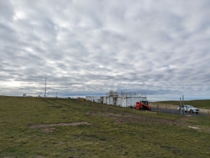
The Cloud And Precipitation Experiment at kennaook (CAPE-k) operated from April 2024 to October 2025 in northwestern Tasmania. As part of the campaign, ARM deployed one of its mobile observatories at the Kennaook / Cape Grim Baseline Air Pollution Station. ARM measurements augmented routine aerosol data collected at the station and provided extensive cloud, precipitation, and radiation measurements to complement the existing station data.
Researchers are analyzing CAPE-k data to learn more about aerosol-cloud-precipitation interactions and help reduce a large source of uncertainty in earth system models.
- ORAL SESSION—12: High-Latitude Mixed-Phase Cloud Processes
Wednesday, January 28, 4:30–6 p.m., Room 371E (Convention Center)
Reported CAPE-k presentation:- 12.5: Clouds Radiative Effects at High Latitudes: Insights from Observations during the CAPE-k and COMBLE Field Campaigns. Yongjie Huang, Center for Analysis and Prediction of Storms, University of Oklahoma.
Follow Us:


Keep up with the Atmospheric Observer
Updates on ARM news, events, and opportunities delivered to your inbox
ARM User Profile
ARM welcomes users from all institutions and nations. A free ARM user account is needed to access ARM data.


