

Researchers Apply ARM Data to Refine Aerosol-Cloud Interaction Simulations
Published: 18 February 2026
E3SM regional testbed enables more realistic model predictions
Aerosols play a crucial role in the formation of clouds and precipitation, as well as affecting their duration and the amount of sunlight they reflect. However, representation of these complex multiscale aerosol-cloud-precipitation interactions remains a significant source of uncertainty in earth system models (ESMs).
Atmospheric scientists and modelers supported by the U.S. Department of Energy’s (DOE’s) Enabling Aerosol-cloud interactions at GLobal convection-permitting scalES (EAGLES) project addressed this uncertainty in a December 2025 paper published in the Journal of Advances in Modeling Earth Systems.
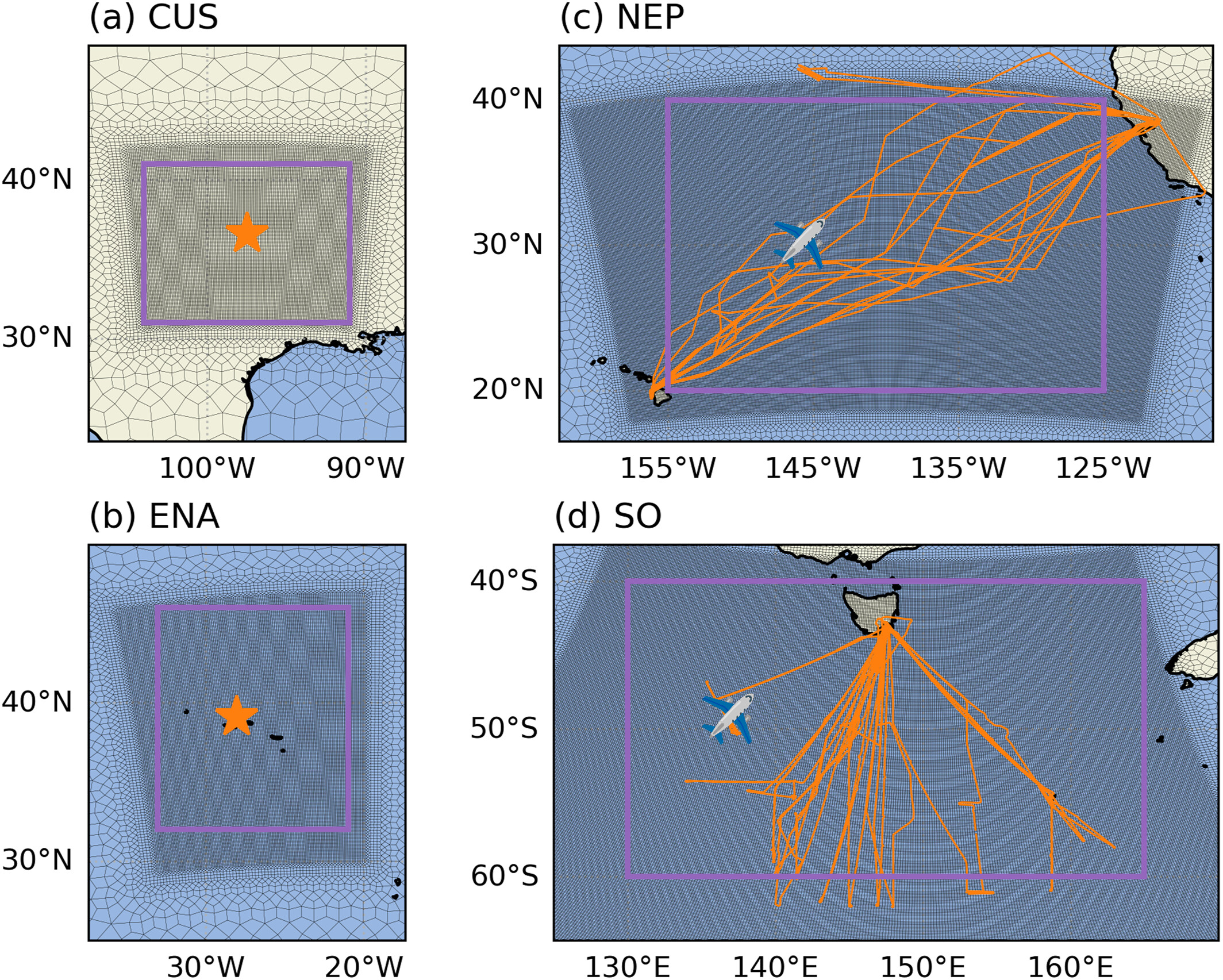
The research team employed a digital testbed approach, comparing the model against the data. They used the second version (v2) of DOE’s Energy Exascale Earth System Model (E3SM) with a regionally refined mesh (RRM) to analyze how kilometer-scale resolution enhances simulations of aerosols and clouds across different regions.
Models run at kilometer-scale resolution are known as “convection-permitting” because they feature grid spacing fine enough to explicitly represent the dynamics of convective storms. RRM is a computational technique in ESMs that applies a higher-resolution grid only in specific areas of scientific interest to reduce computational cost.
Traditional models with coarse resolution (typically 100-kilometer scale) struggle to adequately represent aerosol-cloud-precipitation interactions because the processes involved operate across multiple scales. Using E3SM at kilometer-scale resolution with RRM, researchers simulated a range of aerosol and cloud conditions across distinct geographic regions and compared the simulations with observations. The study integrated in situ cloud and microphysical properties with additional constraints on cloud cover, condensation, and precipitation.
By examining key relationships among cloud properties, aerosol life cycles, and precipitation patterns, the team sought to support the development of more reliable ESMs for predicting atmospheric processes.
The authors conclude that higher-resolution grid scaling improves the representation of certain aspects of these interactions. However, this is not sufficient to universally improve the accuracy of aerosol and cloud properties. They emphasize the need for additional refined process representations to achieve more precise aerosol and cloud simulations.
Harnessing Observations
Field campaign data from DOE’s Atmospheric Radiation Measurement (ARM) User Facility played a central role in the evaluation of the study’s simulations. Researchers analyzed cloud microphysics, aerosol characteristics, and precipitation data from four regions: the central United States, Southern Ocean, eastern North Atlantic, and northeastern Pacific.
Researchers used observational data from a variety of ARM campaigns, including Holistic Interactions of Shallow Clouds, Aerosols, and Land-Ecosystems (HI-SCALE) and Aerosol and Cloud Experiments in the Eastern North Atlantic (ACE-ENA). While these campaigns provided in situ measurements of aerosol and cloud properties, satellite observations complemented the ARM data sets, enabling a detailed comparison with simulation results.
“The ARM data enabled us to constrain our simulations with observational reality, improving our ability to capture processes like droplet nucleation and precipitation dynamics,” says Po-Lun Ma, an atmospheric scientist at Pacific Northwest National Laboratory (PNNL) in Washington state and the EAGLES project’s principal investigator.
The team also used data sets from the National Science Foundation National Center for Atmospheric Research’s Cloud Systems Evolution in the Trades (CSET) campaign over the North Pacific and the multi-agency Southern Ocean Clouds, Radiation, Aerosol Transport Experimental Study (SOCRATES).
Advances and Challenges
The study revealed that, although higher-resolution models significantly improve interactions between aerosols and clouds, biases—offsets relative to observations—persist in specific aerosol and cloud regimes. Higher resolution improves predictions of heavy precipitation in storm-prone areas but increases errors in light drizzle in marine regions. Changes in cloud cover and liquid water path (LWP) align more closely with satellite data, but surface-based comparisons sometimes favor coarser-resolution models.
From an aerosol perspective, kilometer-scale simulations highlighted shifts in aerosol size distributions, with increased ultrafine particles from new particle formation and reduced accumulation-mode aerosols (fine atmospheric particles, typically 0.1 to 1.0 μm in diameter) due to efficient precipitation-driven scavenging, a natural process in which rain, snow, or fog removes aerosol particles from the atmosphere.
These changes result in fewer cloud condensation nuclei (CCN) and lower cloud droplet numbers (Nd), altering the reflective properties of clouds and influencing cloud lifetimes.
“While absolute biases remain, the kilometer-scale model demonstrates better coupling between aerosols and clouds,” says Meng Huang, an atmospheric scientist at PNNL and lead author of the study. “Relationships like CCN-Nd concentration and LWP-Nd concentration move closer to observations, offering more realistic interactions.”
The study also cautions that resolution alone cannot resolve all inaccuracies. Improvements in the physical and chemical representations of aerosols, cloud microphysics, and scavenging mechanisms are still necessary to address persistent prediction errors.
Supporting Energy Reliability
This research has implications beyond atmospheric science. Because aerosol-cloud interactions influence precipitation patterns, accurate simulations of these processes are needed to understand water availability for energy.
Enhanced predictability of weather patterns and storm behavior also supports the reliability of energy distribution, reducing risks to the power grid during extreme weather events. “Addressing biases in aerosol-cloud processes helps us improve forecasts, which are vital for supporting energy resilience and operational stability across the U.S.,” says Ma.
By enhancing physical and chemical process representations in ESMs, researchers are opening the door for more realistic atmospheric simulations. Shared data sets and configurations from the testbed will support collaboration, enabling further progress.
Author: Mike Wasem, Staff Writer, Pacific Northwest National Laboratory
# # #ARM is a DOE Office of Science user facility operated by nine DOE national laboratories.
Follow Us:


Keep up with the Atmospheric Observer
Updates on ARM news, events, and opportunities delivered to your inbox
ARM User Profile
ARM welcomes users from all institutions and nations. A free ARM user account is needed to access ARM data.


