

PhD Student Helps Bring Py-ART, Open Radar Data to the Masses
Published: 17 March 2026
Alfonso Ladino-Rincon wants to support growth of open science community

More than a decade ago, Alfonso Ladino-Rincon discovered the U.S. Department of Energy’s Atmospheric Radiation Measurement (ARM) User Facility and the Python ARM Radar Toolkit (Py-ART) through YouTube.
Ladino-Rincon was looking online for resources to help him plot radar data as a radar meteorologist and software developer with the Colombian weather service. That is when he found a 2014 video of Scott Collis, a scientist from Argonne National Laboratory in Illinois, introducing Py-ART, an open-source toolkit in the Python programming language. Py-ART provides algorithms and utilities to help users examine, process, and analyze radar data from ARM and other entities.
Through that video, Ladino-Rincon got the weather service to start using Py-ART operationally. He also began using Py-ART as he worked toward his master’s degree in meteorology.
Now a PhD student in atmospheric sciences at the University of Illinois Urbana-Champaign, Ladino-Rincon still uses Py-ART for his research while working on a variety of other projects aimed at bringing radar data and open science to a broader audience.
“We want a lot of people working on this because as we get more people interested, we can keep the community growing, but also the community will give us some sort of feedback so we can keep going and creating knowledge and doing science,” says Ladino-Rincon.
Collis, Py-ART’s science lead, has collaborated with Ladino-Rincon multiple times since they met at a 2015 radar conference. Collis sees Ladino-Rincon as part of the next generation that will move open radar science forward.
“He’s come at open science and radar meteorology with fresh eyes and has really built connections to the data sciences community,” says Collis.
Recipe for Success
Ladino-Rincon wrote a section of a Project Pythia radar cookbook that teaches users how to work with weather radar data using Python. Most of this citable scientific work focuses on reading, correcting, and visualizing radar data with Py-ART.
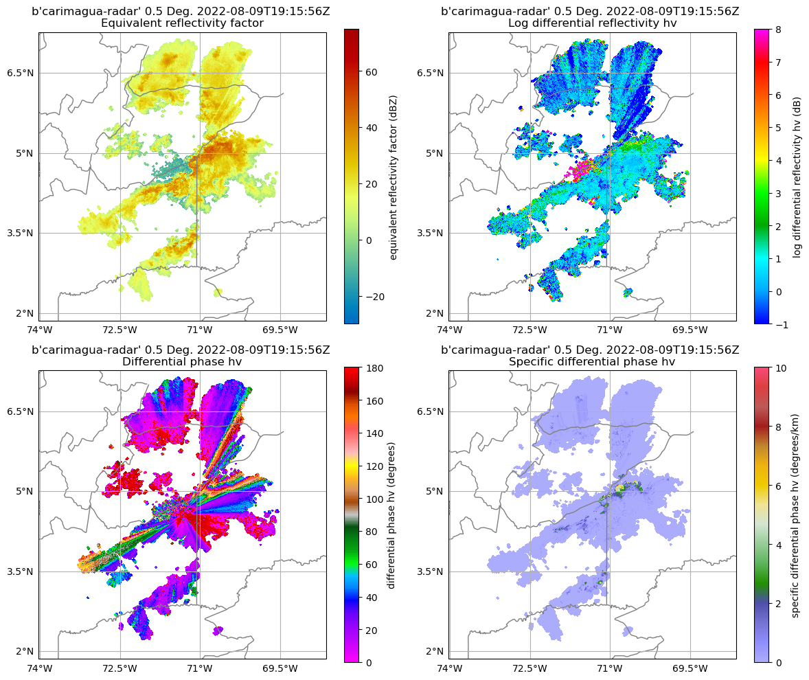
The cookbook contains an example workflow from Ladino-Rincon for using a variety of specific differential phase retrieval methods for dual-polarization radars. (Specific differential phase, defined by NOAA as a comparison of the phase shift between a radar’s horizontal and vertical pulses, is useful for rainfall rate estimation and noise reduction.)
In his example workflow, Ladino-Rincon shows how to access weather radar data, read and create a plot with the data, and compare the specific differential phase from the radar data with the specific differential phases retrieved from three other methods.
The radar cookbook is regularly used at ARM summer schools to teach students about using radar data in Py-ART. It will be used again in May 2026 by students attending ARM’s Big Open Data Science Summer School in Oklahoma.
Summer Schools Spark Collaboration
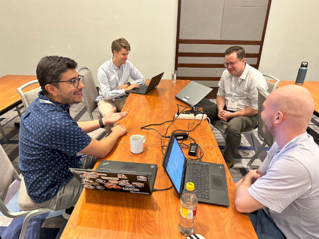
In May 2024, Ladino-Rincon dived deeper into ARM data by attending an ARM open science summer school at Cleveland State University in Ohio. “I had a lot of questions in terms of how I could access the data in an optimized way,” he says.
During the weeklong program, co-organized by Collis and then-Argonne colleague Max Grover, students learned how they could use open-source tools to connect field campaign observations with high-resolution model data. Ladino-Rincon got to see fellow students learn about radar data and Py-ART by referring to the radar cookbook he co-authored.
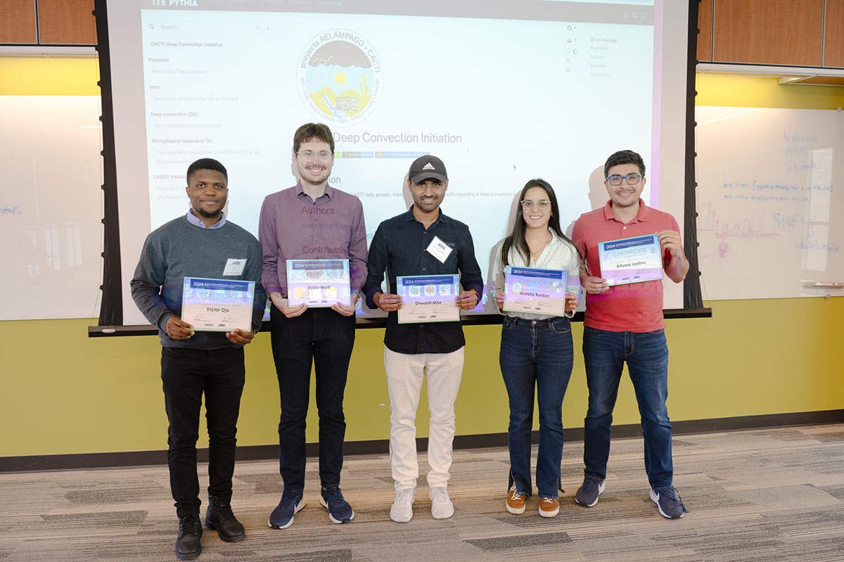
The students worked in smaller teams to answer unique science questions related to ARM atmospheric observatories or field campaigns. Ladino-Rincon’s group focused on deep convection initiation during ARM’s 2018–2019 Cloud, Aerosol, and Complex Terrain Interactions (CACTI) campaign in Argentina. The team explored how deep convection initiation is controlled by local and regional meteorological conditions as well as geography.
For their project, Ladino-Rincon and his teammates used CACTI data from the Large-Eddy Simulation (LES) ARM Symbiotic Simulation and Observation (LASSO) activity. LASSO brings together ARM measurements and high-resolution simulations to support model development and process studies.
“Everything was just a matter of trying to see how you do science not only with radar, but also with other sources of information,” says Ladino-Rincon.
The Jupyter Notebooks from all four of the 2024 ARM summer school group projects remain available on the GitHub software development platform.
In November 2025, Ladino-Rincon published his first paper using ARM data. He and his co-authors, including lead author Zeen Zhu, who completed a 2018 ARM summer training program in Oklahoma, combined ARM observations and modeling to show how giant cloud condensation nuclei can help trigger drizzle formation in low-level marine clouds.
The team’s research collaboration began during a 2023 radar science summer school at Stony Brook University in New York, further highlighting the power of summer schools and training events.
Spreading the Word About Open Radar Data
Ladino-Rincon seeks out opportunities to speak to new audiences about making radar data more accessible through open science. He has presented at various conferences, including the 2025 American Meteorological Society (AMS) Annual Meeting and 2024 European conference on RADar in meteorology and hydrology (ERAD), on using FAIR principles (Findability, Accessibility, Interoperability, and Readability) to efficiently manage meteorological radar data.
In addition, Ladino-Rincon has shared his radar and open science expertise through teaching and co-leading several radar courses.
The most recent radar course took place in August 2025 in Toronto, Canada. Ladino-Rincon was an instructor with Collis and other radar science experts from ARM, Colorado State University, and the National Science Foundation National Center for Atmospheric Research during an open radar science short course at the 41st International Conference on Radar Meteorology, hosted by AMS.
Advancing Open Radar Science
Ladino-Rincon is also involved in developing and enhancing tools that make it easier to use radar data and help advance open radar science.
In October 2025, Ladino-Rincon and his graduate advisor, Stephen Nesbitt, published a paper introducing their RadarDataTree open-source framework. RadarDataTree is designed to organize individual radar data files and turn them into FAIR-compliant data sets that can be hosted and used in the cloud. These are important steps in making data sets ready for use by artificial intelligence.
Ladino-Rincon is a contributor to a Python package called xarray (pronounced “ex-array”). The xarray package provides data models for working with labeled collections of data values arranged across one or more dimensions, such as time, location, and height. It also includes a library of functions for advanced data analysis and visualization.
During the 2025 open radar science short course in Toronto, Ladino-Rincon introduced students to xradar, a tool he developed with scientists at Argonne and other institutions to read and organize weather radar data with xarray.
Initial integration of xarray and xradar into Py-ART has taken place. Continued integration of xarray and xradar is part of the next Py-ART road map, which will serve as a guide for further Py-ART development. The new road map is planned for publication in early spring 2026.
Ladino-Rincon will play a key role in pushing this integration forward.
“He is a key sounding board as a power user and developer,” says Collis.
Author: Katie Dorsey, Staff Writer, Pacific Northwest National Laboratory
# # #ARM is a DOE Office of Science user facility operated by nine DOE national laboratories.
Follow Us:


Keep up with the Atmospheric Observer
Updates on ARM news, events, and opportunities delivered to your inbox
ARM User Profile
ARM welcomes users from all institutions and nations. A free ARM user account is needed to access ARM data.


