

Improved Method to Temporally Interpolate Radiosonde Profiles in the Convective Boundary Layer
Submitter
von Klitzing, Linus — University of Hohenheim
Turner, David D.
— NOAA Global Systems Laboratory
Area of Research
Atmospheric Thermodynamics and Vertical Structures
Journal Reference
von Klitzing L, D Turner, D Lange, and V Wulfmeyer. 2026. "Improved method for temporally interpolating radiosonde profiles in the convective boundary layer." Atmospheric Measurement Techniques, 19(1), 10.5194/amt-19-359-2026.
Science
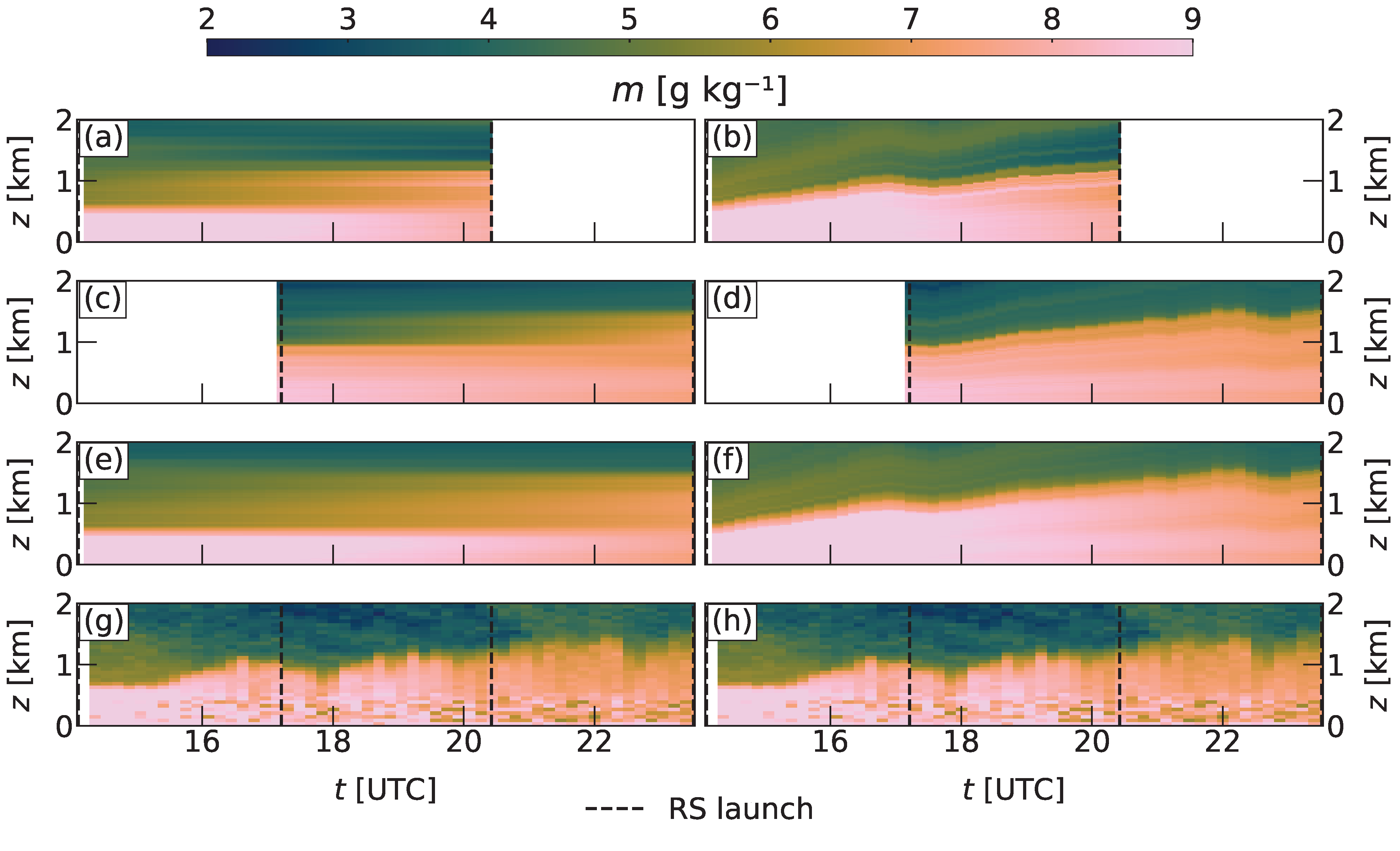
Time-height cross-sections of water vapor mixing ratio m for 24 June 2019, between 14:29 and 23:33 UTC, for the radiosonde interpolation on a standard height grid (a, c, e), on a normalized height grid (b, d, f), and from a continuously measuring Raman lidar (g, h) as a reference. Taken from von Klitzing et al., Atmos. Meas. Tech., 2026. The utilized colormap is from Crameri et al., Nat. Commun., 2020.
Radiosondes are considered the gold standard for measuring profiles of temperature, humidity, and wind, but their temporal resolution is often too coarse for many applications. This study proposes a new method using a normalized height grid in the temporal interpolation process that yields more accurate profiles in the convective boundary layer, i.e., the turbulent atmospheric layer between the surface and the free troposphere.
Impact
This new interpolation method provides temporally high-resolution profiles of humidity, temperature, and potential temperature in the convective boundary layer, even if there are only radiosonde soundings and a planetary boundary layer height estimate available. This enables measurement facilities with limited instrumentation to produce the presented output without additional remote sensing capabilities.
Summary
This work capitalizes on the fact that mean potential temperature and humidity profiles follow a well-defined vertical structure in the convective boundary layer. Turbulent mixing produces relatively uniform profiles within this layer, which are generally capped by an inversion. The presented technique exploits this feature by interpolating the soundings on a height grid that is normalized with the height of the convective boundary layer, i.e., the altitude of that inversion, resulting in a profile consistent with exactly this physically expected structure. Standard interpolation techniques operate on a normal height grid and cannot preserve this layered structure, inevitably leading to inferior results for this specific situation.
Follow Us:


Keep up with the Atmospheric Observer
Updates on ARM news, events, and opportunities delivered to your inbox
ARM User Profile
ARM welcomes users from all institutions and nations. A free ARM user account is needed to access ARM data.


