

Compare Modeled and Observed Clouds at COMBLE With ARM Radar Simulator Product
Published: 22 February 2025
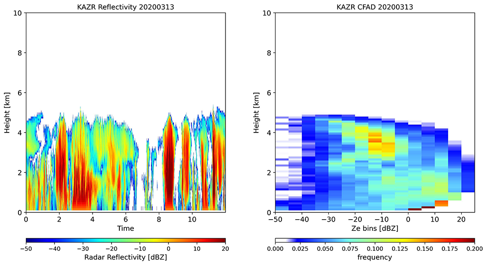
To facilitate the direct comparison of earth system model outputs with its ground-based radar measurements, the Atmospheric Radiation Measurement (ARM) User Facility produces joint histograms of radar reflectivity and height with its cloud radar simulator. The simulator converts model-calculated cloud properties to what a cloud radar can observe. Scientists can compare the observed joint histograms, also called contoured frequency altitude diagrams (CFADs), with outputs from radar simulators used in earth system models.
ARM has released a CFAD product from the Ka-Band ARM Zenith Radar (KAZR) that operated near Andenes, Norway, as part of the 2019–2020 Cold-Air Outbreaks in the Marine Boundary Layer Experiment (COMBLE). The new KAZRCFAD product contains vertically regridded best-estimate reflectivity and joint histograms of best-estimate reflectivity and height up to 20 kilometers.
ARM radar CFADs are generated from the Active Remote Sensing of CLouds (ARSCL) product, and they only include clouds detected by cloud radar. In the case of the KAZRCFAD data from COMBLE, the CFADs were generated using the best-estimate radar reflectivities in the arsclkazr1kollias datastream from the KAZR Active Remote Sensing of CLouds (KAZRARSCL) product.
The original temporal and vertical resolutions of the best-estimate radar reflectivity in KAZRCFAD are four seconds and 100 meters. The joint histograms are created for every hour with a 100-meter vertical resolution to capture both the diurnal variability of clouds and their fine vertical structures. The dBZ values are binned by each 5 dB in the range of minus 50 dBZ to 25 dBZ.
KAZRCFAD is available in evaluation mode for the full duration of the COMBLE campaign from December 1, 2019, to May 31, 2020.
Scientists can use the KAZRCFAD data from COMBLE now, including for comparison with radar simulators such as the Earth Model Column Collaboratory (EMC2) and version 2 of the Cloud Feedbacks Model Intercomparison Project (CFMIP) Observation Simulator Package (COSP2.0) used in earth system models.
Find more information about CFAD products on this ARM cloud radar simulator web page or in Zhang et al. (2018).
Feedback on the KAZRCFAD evaluation data is welcome. If you have questions or suggestions, please contact developer Yuying Zhang or ARM translator Shaocheng Xie.
Users can access the KAZRCFAD data from the ARM Data Center. (To download the data, first create an ARM account.)
To cite the data, please use doi:10.5439/1876547.
Reference: Zhang Y, S Xie, S Klein, R Marchand, P Kollias, E Clothiaux, W Lin, K Johnson, D Swales, A Bodas-Salcedo, S Tang, J Haynes, S Collis, M Jensen, N Bharadwaj, J Hardin, and B Isom. 2018. “The ARM Cloud Radar Simulator for Global Climate Models: A New Tool for Bridging Field Data and Climate Models.” Bulletin of the American Meteorological Society, 99(1), https://doi.org/10.1175/BAMS-D-16-0258.1
Follow Us:


Keep up with the Atmospheric Observer
Updates on ARM news, events, and opportunities delivered to your inbox
ARM User Profile
ARM welcomes users from all institutions and nations. A free ARM user account is needed to access ARM data.


