

ACAPEX
ARM Cloud Aerosol Precipitation Experiment (ACAPEX)
14 January 2015 - 12 February 2015
Lead Scientist: L. Ruby Leung
Observatory: AMF (ARM Mobile Facility) - ACX
The western United States receives precipitation predominantly during the cold season when storms approach from the Pacific Ocean. The snowpack that accumulates during winter storms provides about 70-90 percent of water supply for the region. Understanding and modeling the fundamental processes that govern the large precipitation variability and extremes in the western U.S. is a critical test for the ability of climate models to predict the regional water cycle, including floods and droughts. Two elements of significant importance in predicting precipitation variability in the western U.S. are atmospheric rivers and aerosols. Atmospheric rivers (ARs) are narrow bands of enhanced water vapor associated with the warm sector of extratropical cyclones over the Pacific and Atlantic oceans. Because of the large lower-tropospheric water vapor content, strong atmospheric winds, and neutral moist static stability, some ARs can produce heavy precipitation by orographic enhancement during landfall on the U.S. West Coast. While ARs are responsible for a large fraction of heavy precipitation in that region during winter, much of the rest of the orographic precipitation occurs in post-frontal clouds, which are typically quite shallow, with tops just high enough to pass the mountain barrier. Such clouds are inherently quite susceptible to aerosol effects on both warm rain and ice precipitation-forming processes.
This campaign consisted of the deployment of the ARM Mobile Facility 2 (AMF2) and the ARM Aerial Facility (AAF) Gulfstream-1 aircraft in a field campaign called ARM Cloud Aerosol Precipitation Experiment (ACAPEX), which took place in conjunction with CalWater 2, a NOAA field campaign. The joint CalWater 2/ACAPEX field campaign aimed to improve understanding and modeling of large-scale dynamics and cloud and precipitation processes associated with ARs and aerosol-cloud interactions that influence precipitation variability and extremes in the western U.S. The observational strategy consisted of the use of land and offshore assets to monitor:
- the evolution and structure of ARs from near their regions of development
- the long-range transport of aerosols in the eastern North Pacific and potential interactions with ARs
- how aerosols from long-range transport and local sources influence cloud and precipitation in the U.S. West Coast, where ARs make landfall and post-frontal clouds are frequent.
The AMF2 was deployed on a research vessel offshore and provided critical measurements to quantify the moisture budget and cloud and precipitation processes associated with ARs and to characterize aerosols and aerosol-cloud-precipitation interactions associated with aerosols from long-range transport in the Pacific Ocean. The G-1 probed the clouds that form over the ocean and their transformations upon landfall as well as the orographic effects over the coastal range and the Sierra Nevada. The G-1 flights provided the critical information needed for comparing the simulated and observed processes of the vertical profiles of cloud microstructure and the resultant precipitation initiation and glaciation. This allowed the development and validation of more realistic simulations that replicated the aircraft measurements and thus quantify more reliably the entities that cannot be obtained directly by the aircraft measurements to improve understanding and modeling of aerosol-cloud-precipitation interactions. ARM Operational Periods: ARM Mobile Facility 2: 2015.01.12—2015.02.12 ARM Aerial Facility: 2015.01.02—2015.02.27

The NOAA research vessel Ronald H. Brown, above, played host to the AMF2 for ACAPEX. The G-1 returned to McClellan Airfield in Sacramento, California, for flights over the Sierra Nevada and Pacific Ocean.
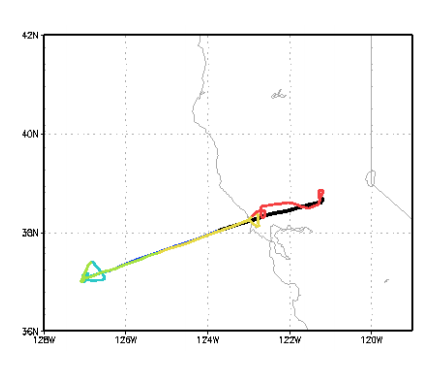
Diagram of the G-1's flight-plan over the Sierra Nevada and Pacific Ocean.
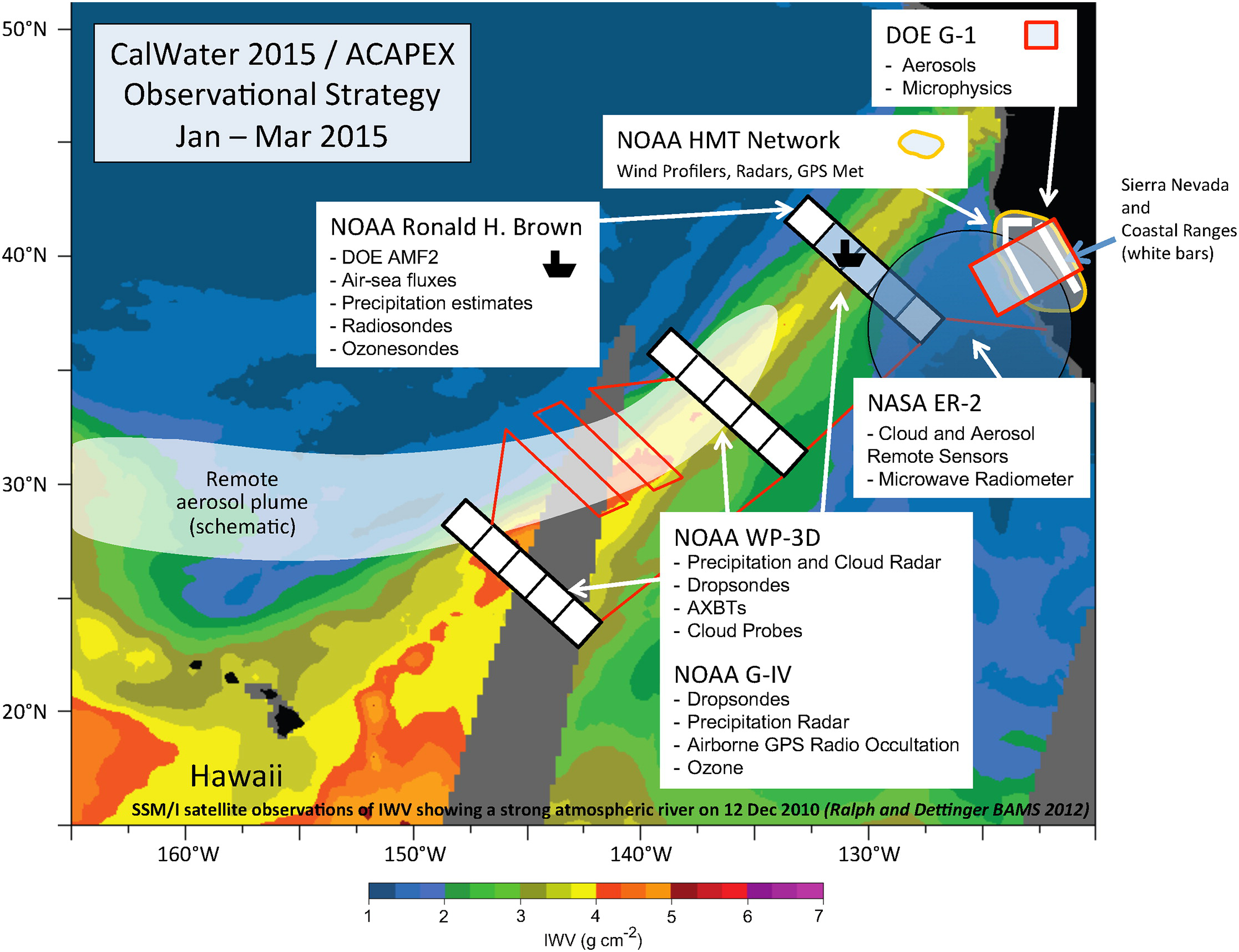
The CalWater2/ACAPEX observational strategy is to use high- and low-altitude aircraft, a ship with the AMF2 and a ground-based network.
Campaign Links
Related Publications
View all- Otuka et al. "Experimental review and recent advances in deep learning techniques for solar irradiance forecasting and prediction". 2026. 10.1016/j.solener.2025.114175.
Related Campaigns
- ARM Cloud Aerosol Precipitation Experiment (ACAPEX): Aerosols and Ocean Science Expedition (AEROSE)
- ARM Cloud Aerosol Precipitation Experiment (ACAPEX): Aerial Observations
- ARM Cloud Aerosol Precipitation Experiment (ACAPEX): Ship-Based Ice Nuclei Collections
Co-Investigators
Chris Fairall
Jiwen Fan
Samson Hagos
Mimi Hughes
Chuck Long
Kimberly Prather
Marty Ralph
Veerabhadran Ramanathan
Daniel Rosenfeld
Steven Rutledge
Ryan Spackman
Duane Waliser
Hailong Wang
Timeline
Campaign Data Sets
| IOP Participant | Data Source Name | Final Data |
|---|---|---|
| Jonathan Gero | Marine Atmospheric Emitted Radiance Interferometer | Order Data |
| Stephen Springston | Ozone | Order Data |
| Stephen Springston | Particle Soot Absorption Photometer | Order Data |
ACX Data Sources
| Name | Full Name | Browse Data |
|---|---|---|
2DS-AIR
|
2 Dimensional Stereo Probe aboard aircraft | Browse Data |
AAFMERGED
|
ARM Aerial Facility (AAF) Merged VAP for Historical AAF G1 Field Campaigns | Browse Data |
AERI
|
Atmospheric Emitted Radiance Interferometer | Browse Data |
AOS
|
Aerosol Observing System | Browse Data |
AOSMET
|
Meteorological Measurements associated with the Aerosol Observing System | Browse Data |
CCN
|
Cloud Condensation Nuclei Particle Counter | Browse Data |
CCN-AIR
|
Cloud Condensation Nuclei Particle Counter aboard Aircraft | Browse Data |
CEIL
|
Ceilometer | Browse Data |
CEILPBLHT
|
Boundary-layer height data with CEIL | Browse Data |
CEILSHIPCOR
|
Ceilometer Corrected for Ship Motion | Browse Data |
CO-AIR
|
Carbon Monoxide- Airborne | Browse Data |
CPC
|
Condensation Particle Counter | Browse Data |
CPC-AIR
|
Condensation particle counter aboard aircraft | Browse Data |
CSPHOT
|
Sunphotometer | Browse Data |
FCDP-AIR
|
Fast Cloud Droplet Probe aboard aircraft | Browse Data |
GUSTPROBE-AIR
|
Gust Probe aboard aircraft | Browse Data |
HSRL
|
High Spectral Resolution Lidar | Browse Data |
HSRLSHIPCOR
|
HSRL Corrected for Ship Motion | Browse Data |
HTDMA
|
Humidified Tandem Differential Mobility Analyzer | Browse Data |
HVPS-AIR
|
High Volume Precipitation Spectrometer aboard aircraft | Browse Data |
INLETCVI-AIR
|
Inlet for Counterflow Virtual Impactor aboard aircraft | Browse Data |
INLETISOK-AIR
|
Isokinetic Inlet aboard aircraft | Browse Data |
IRT
|
Infrared Thermometer | Browse Data |
KAZR
|
Ka ARM Zenith Radar | Browse Data |
KAZRSHIPCOR
|
KAZR Ship Motion Correction | Browse Data |
LSSONDE
|
Microwave Radiometer-Scaled Sonde Profiles | Browse Data |
MET-AIR
|
Meteorological Instrumentation aboard Aircraft | Browse Data |
MPL
|
Micropulse Lidar | Browse Data |
MPLCMASK
|
Cloud mask from Micropulse Lidar | Browse Data |
MPLPOLFSSHIPCOR
|
MPL Corrected for Ship Motion | Browse Data |
MWACR
|
Marine W-Band (95 GHz) ARM Cloud Radar | Browse Data |
MWACRSHIPCOR
|
MWACR Ship Motion Correction | Browse Data |
MWR
|
Microwave Radiometer | Browse Data |
MWR3C
|
Microwave Radiometer, 3 Channel | Browse Data |
NAV
|
Navigational Location and Attitude | Browse Data |
NAV-AIR
|
Navigational Location, Motion, and Attitude for Airborne Platforms | Browse Data |
NAVBE
|
Navigational Location and Attitude Best Estimate | Browse Data |
NAVMET-AIR
|
Navigation and Met Data from multiple sensors on airborne platform | Browse Data |
NEPHELOMETER
|
Nephelometer | Browse Data |
NEPHELOMETER-AIR
|
3-Wavelength integrating nephelometer aboard aircraft | Browse Data |
OZONE
|
Ozone Monitor | Browse Data |
OZONE-AIR
|
Ozone Monitor aboard Aircraft | Browse Data |
PBLHT
|
Planetary Boundary Layer Height | Browse Data |
PCASP-AIR
|
Passive cavity aerosol spectrometer aboard aircraft | Browse Data |
PRP
|
Portable Radiation Package | Browse Data |
PSAP
|
Particle Soot Absorption Photometer | Browse Data |
RWP
|
Radar Wind Profiler | Browse Data |
SONDE
|
Balloon-Borne Sounding System | Browse Data |
S-TABLE
|
Stabilized Platform | Browse Data |
TSI
|
Total Sky Imager | Browse Data |
UHSAS-AIR
|
Ultra-High Sensitivity Aerosol Spectrometer aboard aircraft | Browse Data |
Follow Us:


Keep up with the Atmospheric Observer
Updates on ARM news, events, and opportunities delivered to your inbox
ARM User Profile
ARM welcomes users from all institutions and nations. A free ARM user account is needed to access ARM data.


