

CoURAGE Campaign Closes
Published: 28 January 2026
A yearlong effort reveals insights into atmospheric interactions across urban, rural, and coastal areas
In late 2024, staff from the U.S. Department of Energy’s (DOE’s) Atmospheric Radiation Measurement (ARM) User Facility supported the launch of an ambitious field campaign in and around Baltimore, Maryland.
The Coast-Urban-Rural Atmospheric Gradient Experiment (CoURAGE), led by Pennsylvania State University professor Kenneth Davis, captured observations of Baltimore’s atmospheric environment and the interplay of urban, rural, and coastal air.
Davis oversaw a team of 27 co-investigators, including scientists from DOE national laboratories and university faculty, who collaborated throughout the yearlong campaign. CoURAGE completed operations November 30, 2025.
The campaign focused on developing data sets for modeling atmospheric dynamics in urban areas. It was designed to help researchers better understand how different landscapes—from farmland to urban centers to coastal waters—influence the sky above us.
“A lot of people live in coastal cities,” says Davis, “so this campaign’s goals included atmospheric observations and data sets to refine earth system models to better capture localized processes in urban areas.”
Researchers can access CoURAGE data in the ARM Data Center.
Unraveling Urban, Rural, and Coastal Airflows
CoURAGE was built around a simple but powerful question: How does the atmosphere change from the countryside to the city and out to the water’s edge? Understanding this gradient helps scientists understand how surface conditions, such as land cover, and air flows come together to influence atmospheric composition, radiation, and precipitation patterns.
Baltimore’s location made it an ideal natural laboratory. The city is situated between the Appalachian Piedmont to the northwest and the Chesapeake Bay to the southeast, with rolling farmland and open water surrounding a dense urban center. This terrain creates different daily and seasonal effects on temperature, air movement, and particle formation.
Focusing on Urban Scales
A key motivation for the CoURAGE campaign was to expand the capabilities of current earth system models.
“These models were originally conceived for global dynamics and have required adjustments to capture the fine-scale complexities of urban environments,” says Davis. “But with advances in computing and atmospheric observations, researchers now have the ability to simulate atmospheric behavior on city or even neighborhood scales.”
“We need observations (for modeling at these scales),” he adds. Observational data are essential for evaluating and improving numerical modeling systems, which often produce results that differ significantly from reality.
“The truth in the atmosphere is often surprising,” says Davis, highlighting the importance of robust field measurements.
CoURAGE created a unique area of observation unlike any previous field effort in the mid‑Atlantic: It considered the region as a connected system rather than focusing solely on the city.
Taking a Regional Approach
CoURAGE established a four-node regional observation network with strategically positioned instruments:
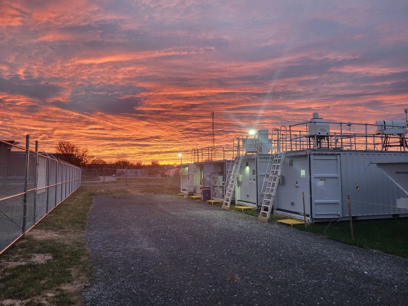
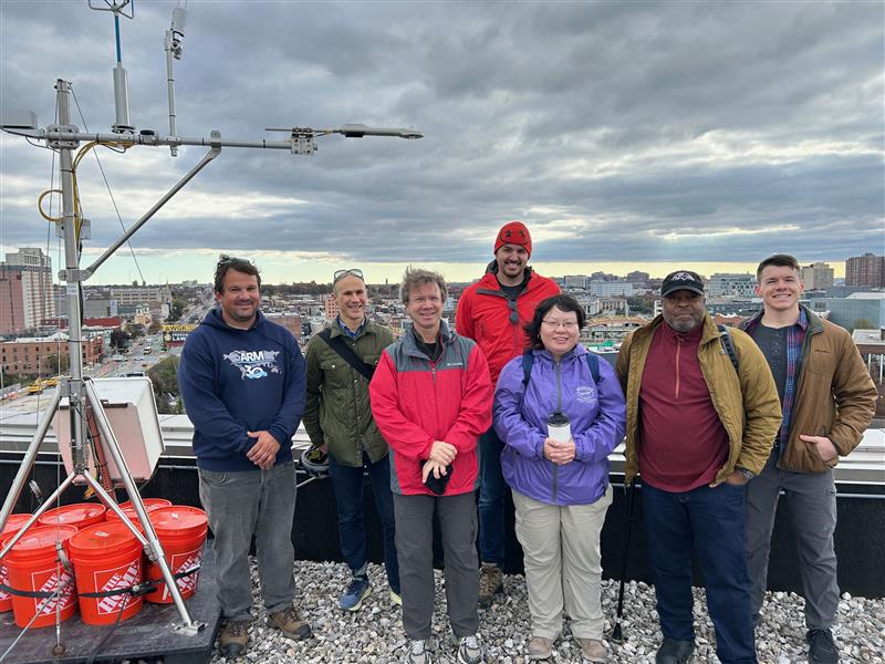
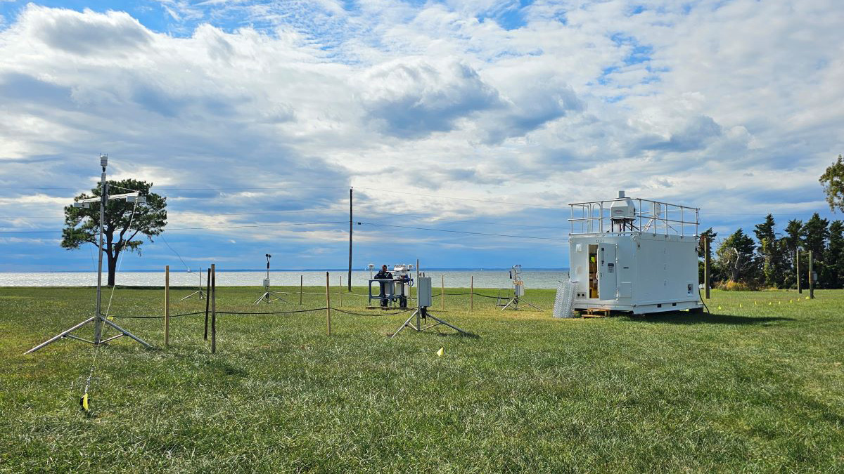
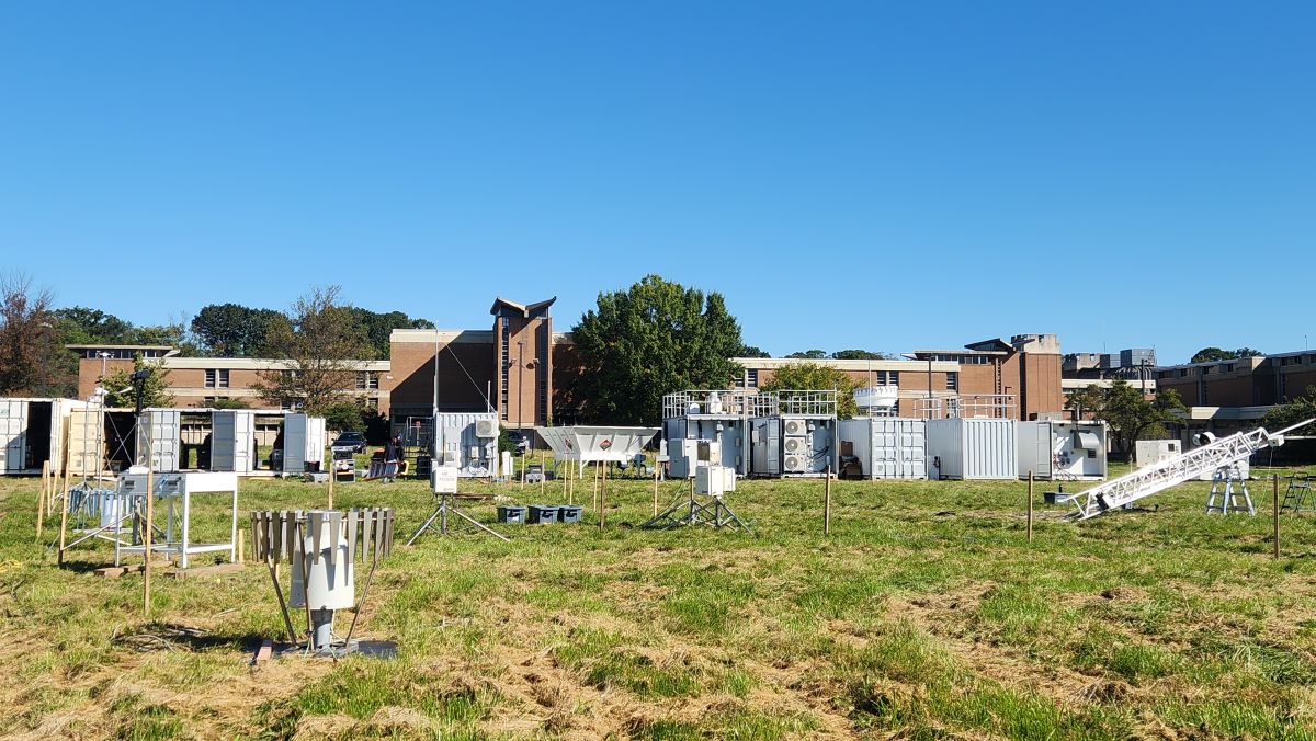
- Urban: the primary site at Morgan State University’s Clifton Park location in northeast Baltimore, featuring an ARM mobile atmospheric observatory that built on observations from the Baltimore Social-Environmental Collaborative, one of DOE’s Urban Integrated Field Laboratories
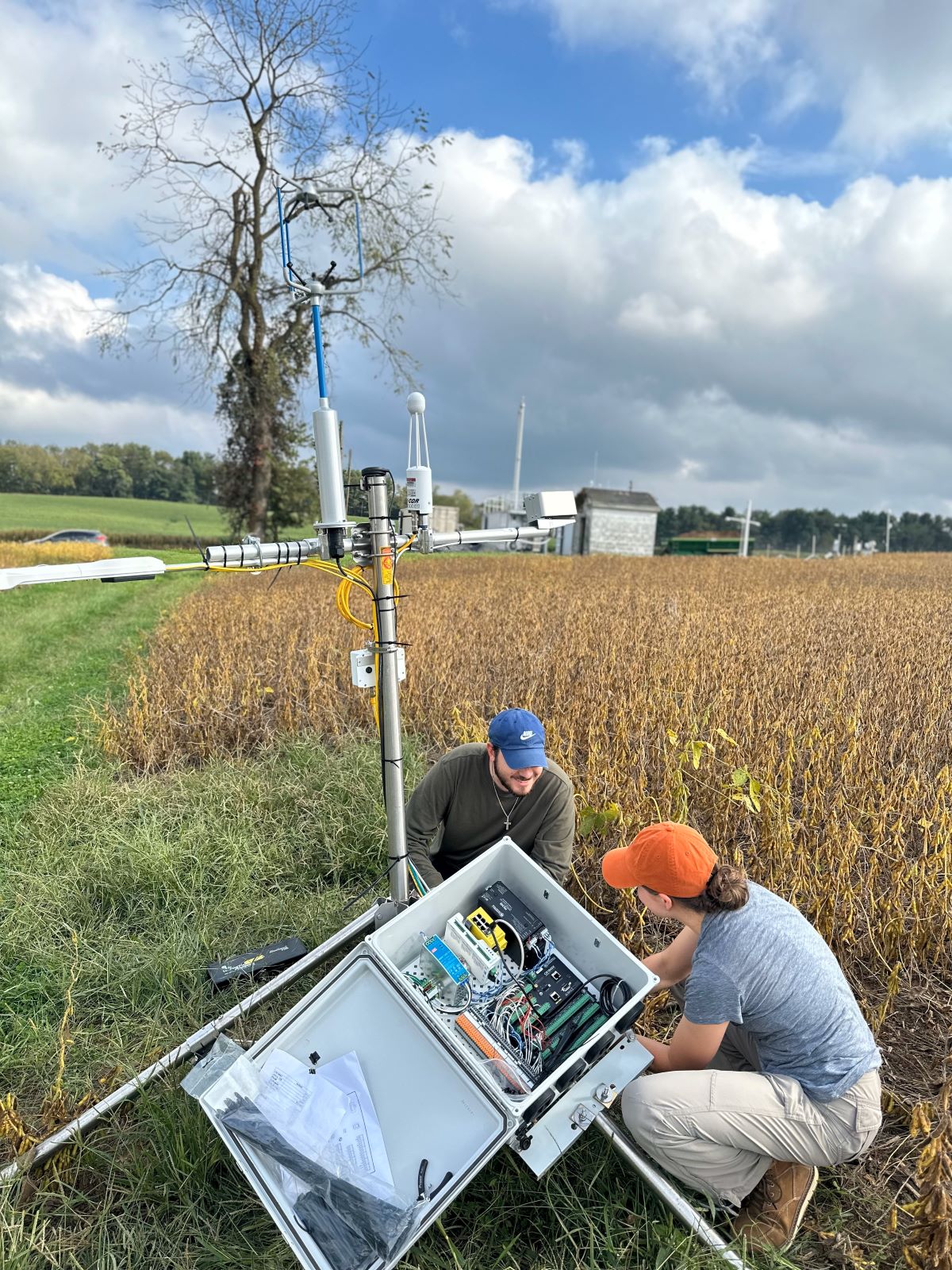
- Upwind Rural: an ARM site northwest of the city in Frederick County
- Bay: an ARM site on Kent Island within the Chesapeake Bay and a launch site for ARM tethered balloon system (TBS) flights on the bay’s eastern shore
- Upwind Urban: observations conducted by the Maryland Department of the Environment and Howard University at Howard’s Beltsville, Maryland, campus.
By the campaign’s launch on December 1, 2024, more than 50 instruments, including lidars, radars, aerosol sensors, and meteorological towers, had been installed across the ARM sites.
Complex Deployment, Challenging Weather
John Bilberry, a member of the ARM field deployment team at Los Alamos National Laboratory in New Mexico, shared how extreme weather emerged as one of the central challenges.
Early in the deployment, frozen mud and rain affected the main and rural sites.
Although Maryland isn’t traditionally associated with tornado activity, Bilberry notes the challenges posed by multiple tornado warnings as well as flooding, insect swarms, and extreme heat.
These heat waves were a significant hurdle during CoURAGE, prompting the team to develop mitigation strategies that will also be useful during ARM’s Desert-Urban SysTem IntegratEd AtmospherIc Monsoon (DUSTIEAIM) campaign in Arizona. DUSTIEAIM is slated to begin in June 2026.
“Heat is actually a lot more challenging than the cold,” says Bilberry, describing how high temperatures caused some instruments to shut down for self-protection. “We learned a lot from the heat waves and developed strategies for keeping the data flowing. The upcoming Arizona deployment will also face high temperatures, making adaptability crucial.”
Regional Testbeds: Bridging Data and Models
CoURAGE campaign observations align with the regional digital testbed concept—collaborative hubs that tie high-resolution field data with earth system models used for energy, infrastructure, and environmental planning.
Testbeds serve as proving grounds for incorporating new data sets into predictive models, helping identify gaps in how large-scale models represent interactions of aerosols, radiation, and surface processes in cities and coastal areas. For example, scientists are using CoURAGE observations to refine components of DOE’s flagship earth system model, the Energy Exascale Earth System Model (E3SM), as well as other modeling frameworks.
The regional digital testbed approach also promotes open collaboration and cross-disciplinary innovation, leveraging advances in artificial intelligence and machine learning to analyze complex data sets.
Measuring the Atmosphere in Flight
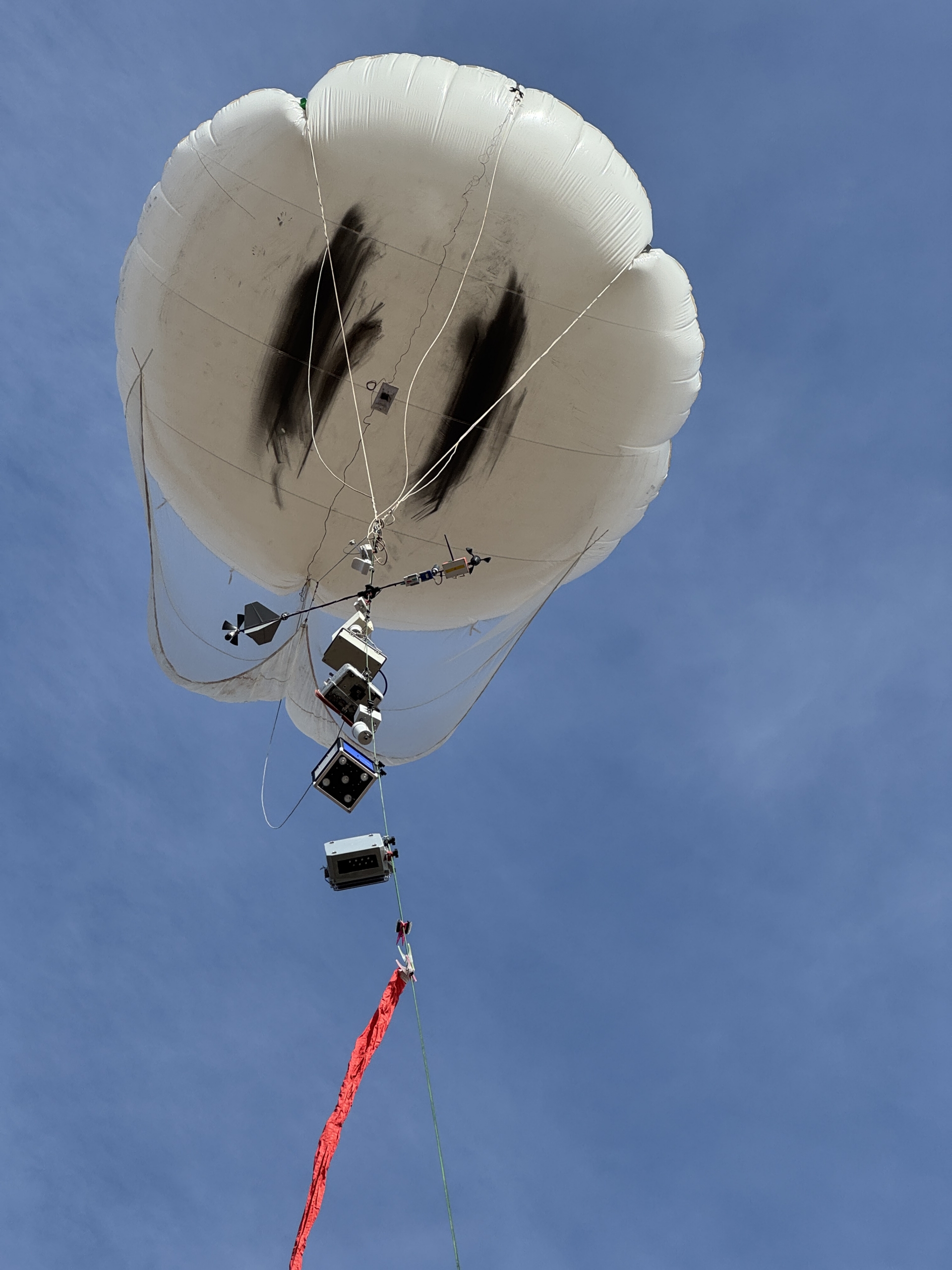
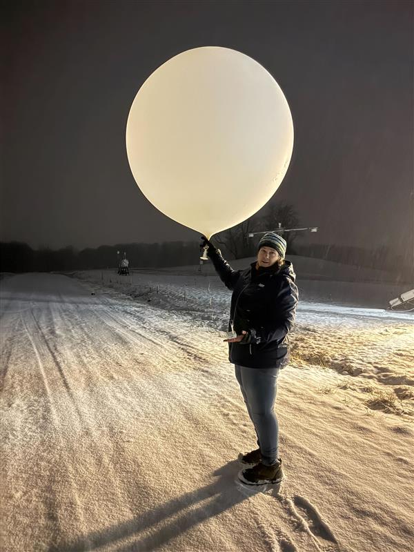
Few campaign components capture the imagination—or attention—quite like a TBS rising in the sky, says Dari Dexheimer, ARM’s lead TBS instrument mentor from Sandia National Laboratories in New Mexico.
During CoURAGE’s intensive operational periods in February and July 2025, ARM staff launched TBS with complex instrument packages high into the boundary layer above the Chesapeake’s shoreline. The boundary layer is the lowest portion of the troposphere and is directly influenced by the Earth’s surface. These flights provided real‑time measurements of temperature, humidity, aerosols, atmospheric gases, and other critical observations at varying altitudes.
TBS operations enabled continuous vertical profiling, complementing remote sensing data from ground instruments and providing rare insight into fine‑scale transitions between the surface and atmosphere.
In July, the TBS team conducted its first dual-balloon flight at the same location. The dual flights let each balloon operate independently of the other, says Dexheimer. For example, while one balloon collects samples at a specific altitude, the other balloon can move up and down within the boundary layer with different payloads.
The TBS data became particularly valuable when linked to wind and aerosol observations, helping scientists examine how bay breezes and the nocturnal low‑level jet distribute aerosols across the region. These patterns are central to understanding how airborne particles move across connected landscapes.
Related Campaigns Explore Regional Dynamics
As the campaign matured through 2025, it became a platform that supported 13 related campaigns under the ARM CoURAGE umbrella.
One example was the Seasonal/Spatial Vertical New Particle Formation (NPF) Variation Study (SSNPF), led by researchers at the University at Albany, who compared aerosol particle formation processes and applied aspects of three-dimensional atmospheric modeling.
The research team built a bridge between CoURAGE observations and data from ARM’s Bankhead National Forest atmospheric observatory in Alabama. This cross‑deployment connection highlights an emerging model for the ARM user community: coupling field data from multiple environments to test universal processes. In this case, it helps refine understanding of how aerosols influence the Earth’s energy balance—essential knowledge for improving predictive simulations.
Campaigns like SSNPF, says Davis, add to the perspectives and measurements of the overall effort.
The January 2026 American Meteorological Society (AMS) Annual Meeting in Houston, Texas, is slated to include a wide range of science presentations featuring data from CoURAGE and related campaigns. For a complete list of talks and posters, visit ARM’s 2026 AMS presentation web page.
Learn more about CoURAGE-related campaigns on ARM’s CoURAGE campaign page.
Data Pave Way for User Research
By its close, CoURAGE had generated 86 terabytes of data, which can be downloaded from the ARM Data Center through ARM’s Data Discovery interface.
ARM also made a growing suite of campaign value-added products accessible to the user community. One of the products combines TBS and ceilometer data to provide unprecedented spatial insights into particle distributions. Other releases include harmonized aerosol and radiation data sets, boundary-layer profiles, merged surface-atmosphere flux analyses, and validated algorithms for characterizing aerosol optical depth and particle chemistry across various land-use conditions.
A significant milestone occurred in September 2025 when ARM introduced simplified metadata and automated quality-control tools tailored to CoURAGE products. Researchers can now incorporate data into their analysis pipelines with minimal formatting efforts, significantly reducing barriers to usage.
Observations, Questions, and Impressions
According to Davis, campaign observations and data have led to several topical inquiries and perspectives:
- Urban heat island effects: Baltimore exhibits a typical summer phenomenon in which city surfaces absorb heat, resulting in a deeper, more turbulent boundary layer. However, Davis observed unexpected variability in the development of the urban boundary layer. Some days showed more substantial urban heat island effects, while on other days, the gap between urban and rural conditions was less noticeable. “It’s mysterious and interesting,” says Davis, noting that synoptic weather conditions—large-scale atmospheric patterns—likely influenced this variation.
- Cloud cover disparities: Early data showed that the rural site consistently had more low-level clouds than the city. Davis hypothesized that this might be due to differences in atmospheric composition, particularly in aerosol hygroscopicity (the tendency of particles to act as condensation nuclei for clouds), as observed during the campaign.
- Low-level jets: Davis described frequent low-level wind jets—maximum sustained wind occurring several hundred meters above the ground—which were “persistent” and observed across the city, rural area, and bay. Documenting their seasonality and potential links to precipitation events in Baltimore could be an ongoing area of study.
- Bay breezes and air quality feedbacks: The Chesapeake Bay was a focus of the campaign. Coastal winds known as “bay breezes” were observed transporting cooler, aerosol-laden air into Baltimore. Davis explained how overnight buildup over the bay can result in daytime haze when winds push air inland. “It will be a benchmark for trying to simulate this structure realistically,” he says.
- Severe weather and heat mitigation: Extreme heat events in Baltimore were observed along with their interactions with urban heat islands and localized weather patterns. Simulation efforts to evaluate mitigation measures such as reflective surfaces, vegetation, and heat-reducing infrastructure might be another area of study, says Davis.
Connecting the Dots: Land, Sea, and Air
Davis predicts that CoURAGE data will continue to provide insights into how Baltimore’s atmospheric environment reflects interactions of air from urban, rural, and coastal regions. These insights also hold promise for informing earth system model representations of similar cities.
“The expectation is that what we’re learning here translates to other coastal cities,” says Davis.
With the campaign concluded, researchers point to an enduring message: Understanding how air moves between coasts, cities, and countrysides is not just an academic puzzle—it’s central to how communities can plan, manage their resources, and adapt to their surroundings.
Author: Mike Wasem, Staff Writer, Pacific Northwest National Laboratory
# # #ARM is a DOE Office of Science user facility operated by nine DOE national laboratories.
Follow Us:


Keep up with the Atmospheric Observer
Updates on ARM news, events, and opportunities delivered to your inbox
ARM User Profile
ARM welcomes users from all institutions and nations. A free ARM user account is needed to access ARM data.


